
Matilija Waterfalls (Amazing!)
Day #915 * Hike #1153 * New Track #901
Matilija Falls - Ojai, CA
Sunday May 19, 2013
My Tripometer: 4 Hourss * 9.75 Miles * +1200 Feet

Riding our bikes up the dirt road
Directions:
Take the 33 North out of Ojai. Set your tripometer; At 3.4 miles past the Fairview and La Luna intersection, veer left up the steep hill. This is Matilija Canyon Road and follow it all the way to the end. The trail begins along the dirt road past the donkeys and peacocks. I've been back here many times and today we will be primarily following the route from:
Day 816: Matilija Wilderness - Flat Rock.

Map to the Waterfalls
To help speed things up, we took our bikes and cheated the first 2.2 miles. About 2 miles of that was a slow easy; crossing two shallow creeks and gaining a gradual 450 feet. (Note, the creeks during the rainy season are often slightly challenging to pass and sometimes icy). The final quarter mile to the unmarked junction was rough, single track, and required walking the bikes...

The unmarked junction
The best way to go from here is right. It is more obvious, easier and it will lead you down past all the attractions; Flat Rock, the creek and all of the camping spots. This is what we did last time but then somehow we looped back and reuniting from the trail on the left.
Today, and according to the map, we will be hiking the 0.7 mile trek on the left which will meet back up with the trail on the right which would otherwise be only 0.6 miles. We ditched our bikes and fought past the slightly unmaintained route. This route takes you down to a tiny stream, poison oak and then back up. It's easy enough to follow...

Overlooking the lower section and canyon walls ahead...

Found a rope; only way to get down from here

No problem!
If the rope had not been there, we would have turned back or figured out another way down. Once we got passed the rope, there was no trail. Essentially continue lower along the dry rocky creek to lower ground. Just before reaching the bottom, you will spot a trail marking on your left...

Bald Hills Trailhead
Ignore this trail - not really much of a trail at all but according to the map, this is a historic way to climb out of this canyon; from 2000 feet to nearly 6000 feet. The map does not give you a mileage counter on it, it's unmaintained and I can only imagine that it would be absolute torture, requiring much bushwhacking, a good compass and skilled topo map reading skills. Yeah, ain't no way I'll be trying this route anytime soon. Better off hiking up the Murietta Divide - Day 775. Better make that an overnight trip, if not two...

Finally reaching the creek, turn left and head upstream

Amazing creek and rock formations

Scamper across the rock and look to the sides for the trails
Unlike many trails which follow the creeks, the trails on the side of this route are fairly close to the stream so it's not too difficult to locate it. That said, you will have to look around and it is impossible to avoid bouldering in many spots to reach the next section. It's nothing too difficult. Heck, my nine year old son did it and so did about a half dozen young women with no shirts. Yup, walking on the hot day coming back from the falls I suspect. Of course, when they saw my son they covered themselves...

Passing a camping spot

In and out of shade, trail and rocks...

blue belly...

little waterfalls

so cool back here - just keep going and going...

break wherever and whenever - not us, just keep going...

another fire pit

awesome spot - water slide ahead

way cool!

climb to your right to get over it
At this point, Ayden was so done. He wanted to turn back. He said this was good enough to be the waterfall - but I knew better. Climb over top...

More spots to camp

Entering the woods, again
We spoke to a guy up here and he said that just a bit up to the left is an open valley which will lead to two little waterfalls and swimming holes. Looking at the map, this area would be known as West Falls. He highly recommended continuing to the valley on the right, which leads to the main Matilija Falls...

West Canyon to the left, passed it...

Continue straight - where do we go from here?

Climb above....

Another fire pit - Best spot yet!
(note - none of these Camps are listed on the map)

Fresh Water Spring
At the time I wasn't thinking about it but this would have been an ideal source to refill our water. It was a hot day and I only brought two water bottles each for this adventure. Big Mistake and No Excuse. Nevertheless, fresh water everywhere and we bypassed it...

Oy, now what? Where do we go???

Up the rope along side this waterfall

leads to another rope...

OMG, Be careful!!!

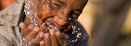
Beautiful Paradise!
We made it up the ropes and from here, so steep, so crazy --- No way, turning back. Made it to the reward but I ordered Ayden to turn back. We could see a rope swing below above the pool on the left and of course the paradise lake under the waterfall directly in front. There was another rope system which would guide you all the way to the falls but I deemed it too dangerous. Actually, Ayden was in front and I could not bypass him because it was too narrow. He was acting way to loose up here, scaring me to death! I probably guided my nine year old further than I should have so at this point, good call to turn back...

TOAD
We took our first official rest at a fire pit heading back. We ate, um, something and saw this toad. We also drank the majority of our remaining water. From there, we hightailed it back quickly. The downward gravity transitioned into a drunken like sloppy stampede. I twisted my ankled yet continued to free fall and bounce of the boulders to the next lower step. We made good time and got back to our bikes with very little water to spare. We rationed it out gently. Then back at the bikes, we walked them for a moment, jumped on and coasted all the way back to the car. Probably only took a total of a dozen pedals. So thankful we had the bikes at this point.
All and all - Amazing Hike! This area is so sick with it. I can imagine coming back many more times to explore the West Falls and more - Beyond - Off Trail, etc...

Pig Crossing!
Always something in Matilija. Careful driving up and down the road passed the homes. This is next year's Easter Ham...