 |
| Jim Morrison Cave |
hike 3.22 MI ON 5/1/2016
DISTANCE
3.22
miles
CLIMB
508 ft
- BEGINS IN:
- Malibu, CA, United States
- CREATED BY:
- Jeremy Jacobus Best Time: 1:02:49
- DESCRIPTION:
- This is a 3.22 mi route in Agoura Hills, CA, United States. The route has a total ascent of 508.36 ft and has a maximum elevation of 2,421.26 ft. This route was created by Jeremy85135177 on 05/01/2016. View other maps that Jeremy85135177 has done or find similar maps.
**Map details are not exact; edited after because I forgot to hit start until after the cave - by the broken down car!
 |
| Optional Trailhead |
Sunday May 1, 2016
Nearly 3 years ago, May 15, 2013, I explored Coral Canyon and randomly came up on what I thought was the Jim Morrison Cave. However, from several comments and further review, I found out that my discovery was false. Click on Day 911 link for driving directions and more details. ***Based on my blog stats, my Day 911 blogpost is my most visited.
 |
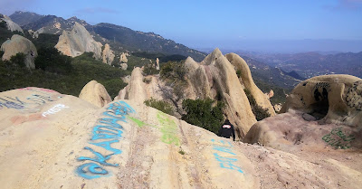
| The Jim Morrison Cave is to the left |
Jim Morrison Cave is now Permanently Closed!
...By some luck of faith, completely random coincidence, my wife heard about the cave and asked some of her bootcampers to go on this date. She told me about her plans the night before and oddly enough, 20 minutes later on Facebook, 1000 Trail Hiker Chris Novak posts an article that this cave is permanently closed to the public. I read the article further and it stated that the closure actually begins on May 2nd - so you bet I'm going out on this hike on this day!
 |
| Jim Morrison Trailhead |
Well, that was easy!!! Last time through this way I straight up jogged right past this side trail. Of course then, there wasn't a big yellow sign advising that the Coral Canyon Cave (Jim Morrison Cave) was closed. The trail is only about a quarter mile from the gate where we parked. It would be a little further from the main parking lot for the Backbone/Castro/Bulldog Trailheads.
Well, now that we are here, walk the very short distance and lets have a look - a final (legal) look:
 |
| Climb through... |
 |
| Across the way... |
Alone, I ventured a few steps away from the trail to the boulder across - Hippo Rock. The trail, if you want to call it that, is sketchy, but short distance and I made it with minor scratching. A few views and some rare overweight photos of me...
Coming back to the Cave, I see my wife and troops were gone. Snap a few photos, let's see where they went...
Here they are, the easy destination of the caves I thought were it. A few more pics in here...
 |
| Jim Morrison Cave - right over there! |
So last time I did see it, but just didn't know that I did. Ahh...
Coming down off the rock, the group began to continue up the fire road to the east (Backbone Trail). I went this direction last time, so I suggested - no - From what I remembered, there was a Bulldog Trail the other way. So, we turned around, bypassed the fire road entrance and continued across the boulders on the Backbone West. We passed the abandoned car, yep remembered that too! And here, we took a break:
 |
| Castro Motorway - Bulldog Motorway |
This is where the legit parking lot for this area is. The low route to the west is the continuation of the Backbone. Instead, we climbed the hill, the Bulldog. And why not, it's only 0.8 miles.
 |
| Trail Junction |
Back to the car, careful crossing the street:
I like the blue house:
Great Sand Dune:
After the Jim Morrison Cave, we stopped off at Neptunes Net and then we climbed the Great Sand Dune! OMG, I barely made it. My leg is still all messed up from a few weeks ago, the injury that placed me in early retirement for my 1000 Hikes Reborn Phase. I have since gained over 20 pounds - which brings me to my Year 2016 Challenge:
52 Pounds in 52 Weeks
New Year's 2016 Weight: 240.9
Week 17 Weight: 258.1
Total Weight Loss: +17.2 Pounds
 |
| Friday April 29, 2016: Week 17 * 258.1 Pounds |
At this point, losing 52 pounds from my original weight seems a bit far fetched. I now have to drop nearly 70 pounds in 35 weeks. I had counted on 1 pound a week loss - now I have to average twice as much. With this injury in my calf; urgh! However, I may have a boost of confidence coming. I hope to find out soon. If it does happen - Competition On! If it doesn't - well, I dunno. For now, I'm on pause mode but at least I got to go to the Doors final concert...
...


