Sunday, January 30, 2011

DAY 77: POTRERO JOHN TRAIL

DAY 77: POTRERO JOHN TRAIL
Miles: 3.25
Elevation Gain650 Feet
Time: 2 Hours
Difficulty (1-10): 2.5
Reward (1-10): 5.0
Description:
Follow the creek on an easy elevation climb in the middle of this vast mountainous region.
Where: Ojai, CA
Directions: From the 101 Freeway in Ventura, exit at the 33 freeway and drive north.  Continue north on the 33 thru Casitas Springs, where the freeway ends.  There are no traffic lights until you get to Oakview.  Keep driving north into Ojai.  After you pass a MacDonalds, Taco Bell and Wendys, turn left on Baldwin.  Less than 500 feet up, turn right onto La Luna.  This road saves time and ends at a 6-way intersection, which includes the 33.  Make sure the traffic is clear and then turn left on the 33 to head north into the mountains.  Most cell phones will lose their coverage within a few miles from this point.  The 33 becomes a very beautiful windy road.  A few miles up you will see the official Los Padres National Forest Sign.  You'll pass through two tunnels.  From La Luna, you'll drive 13.2 miles to Rosevalley.  Keep going straight on the 33.  Drive another 6.2 miles from Rose Valley and look for the small turnout on the right.  You'll see a sign that say Potrero John Trail. 
**MY 77 DAY SUMMARY:  266.25 Miles  +41,325 Feet**


Winner of the Silver Honors Award!
Click Here to Buy or View
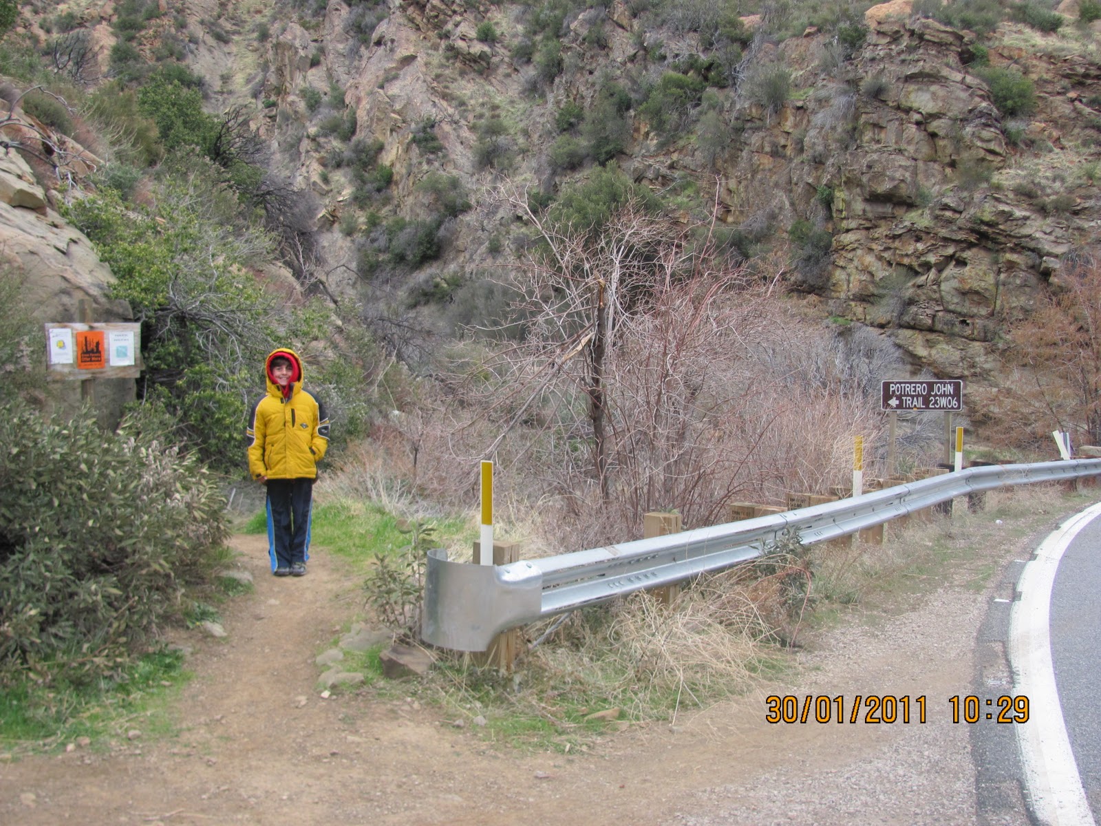
 Potrero John Trailhead

There is only room for one car to park here, possibly two.  Fortunately, no one else was in the mood to hike this hidden wonder today.  There was a mild sprinkle most of the day and at times it came down harder.  But we don't care; we thrive in conditions like this because we're from OH-IO!
 Cookie Dough Mountain
Just past Rosevalley, you will see the Piedra Blanca off to your right from the 33.  My son called it cookie Dough Mountain, so I snapped a picture of it.  There are many great trails off of Rosevalley but on this rainy Sunday with my 7-year-old, I was looking for something simple yet scenic.  The Potrero John won with approval and was well worth the drive!

A Beautiful Manzanita 
The trail is easy to follow and crosses this creak four or five times.  We lost the trail once and began following the creek but my instinct was to look up, I did, and there it was.  There is a solid trail the entire time.  It follows the creek closely for the first mile and then it veers off to the left for just a few minutes until it reunites with the creek again.  The canyon is not very wide so it would be very difficult to get lost.
 My Son spotted a Lady Bug :)

 We walked into a Rainbow

 Many small Waterfalls, most were larger than this but my son was not in those pictures :)

 Ayden was getting anxious so I told him the campsite was up by those trees
 The Campsite!
Good timing because the rain really started to come down.  The trees offered nice shelter but the temperature had dropped and we were both cold.  We didn't make a fire today to eat and warm up.  Instead, I packed us PB&J sandwiches with potato chips. The hike was only 1.6 miles and maybe 600 feet up, but for my son, the rest was well deserved.

To reach this campsite, you have to cross the creek one more time.  The trail continues higher but according to the map, it only goes another quarter mile or so.  This makes sense because the canyon appears to end and unless you intend to rock climb, the gorge will tell you to turn around.  I would have liked to see this for myself but maybe another time.  This would be an ideal place to camp for young kids.  Just an hour hike in but you are away from everything.  I didn't notice much in the way of wildlife and whoever was at this camp last, left 6 chocolate chip cookies by the fire pit.  The cookies were perfectly stacked and in good condition.  Yes, they were tempting but we did not eat them :)

Ayden I hustled back down the stream.  We missed the trail a few times but eventually met up with it as the creek and the trail intersected.  It was nice being back in the Los Padres and I hope to be back soon to take on a 15+ mile overnight expedition!  I took one final picture before we left:

 
 -My battery died in my car!  Good thing I had jumper cables.  I was able to flag someone down and the car jumped ok.  I really need a new car.  This 2001 Ford Focus has no driver side window, no passenger side mirror, dents all over the car and an engine that sounds like a truck.  However, it got me here so what are ya gonna do...


Saturday, January 29, 2011

DAY 76: THE AVENUE TRAIL

DAY 76: THE AVENUE TRAIL
Miles: 1.5
Elevation Gain50 Feet
Time: 45 Minutes
Difficulty (1-10): 1.5
Reward (1-10): 1.0
Description:
An unexpected trail leads us to a harsh reality
Where: Ventura, CA
Directions: From the 101 Freeway in Ventura, exit at the 33 freeway and drive north.  Exit on Stanley and drive straight to Ventura Ave.  Turn right on "The Avenue" and then left on any side street.  We just Lewis.  Park at the end of the street.
**MY 76 DAY SUMMARY:  263 Miles  +40,675 Feet**
In Ventura, The Avenue area is known for poverty and drugs.  This ought to be the nicest area in town because it is situated between the Ventura River and a small mountain just minutes from the ocean.  Instead, a freeway was built next to the river and the homes are all on top of each other.  We passed by what used to be a single family house but it now has five different front doors and addresses under the same roof.  Much of the area is fenced off as industrial and it continues down all the way to School Canyon Road, which I tried hiking on Day 49 http://calihike.blogspot.com/2011/01/day-49-foster-park.html.  This mountain turned out to be an endless system of oil wells and pipe systems.

We had a birthday party to go to early in the day and then the day began to drag on.  Jess agreed to pack up Ayden in the car and aid me on a hike.  I wasn't feeling good at all today but I knew I had to do something.  With a slight fever, stubborn headache, cold sweats and dehydrated mouth, we set forth toward Ojai.  Instead of taking the additional 20 minute drive up the 33, my wife told me about the trail behind the houses off the Avenue.  I didn't really believe her but since she was driving, what are you going to do.  Indeed, there was a trail?!  As soon as we set foot on that trail, she began to reminisce.  Growing up, she lived in this area and often walked this route.  From the end of Lewis Road, we turned left.


This dog was on a trail above us standing like a statue.  We kept going and then the dog ran down the hill and went the other way.  The flat lower trail turned slightly upward and into the ruff.  It was pretty creepy in here. 


 No doubt this was someone's home.  In fact, I believe they were asleep in that green blanket.  We kept walking past and the area opened up to a graffiti ridden jungle.  We saw other self made shelters and cable wires running up a hill.  I imagined that somehow these folks had cable tv out here?


Hoover Dam?  No, just the mountain rock with some strange taboo statue made out of sticks and the head of a doll, Chuckie from Child's Play.  It looked like this area was also used as a skate park for the outlandish child.  The actual skate park is not too far from here.  Anyhow, we continued to a higher trail and reached the top of the area.  There was a fair ocean view but today was hazy.  There was a dirt bike track up here with mild jumps.  I took some pictures of all of it, but will save it for my January video.

We hiked back down and I had the brilliant idea of hiking along the middle trail (where the dog came from).  This is also where the cable was running up to.  On our left tucked away in the brush were several tents.  Peaking ahead, I could see more but then a dog began to bark.  We stopped, my wife turned around and said NO!  The voice of reason escorted me back down the original path. 

This trail worked its way to Deanza park.  I played in a softball league last year and played one game there.  The park is part of a school and is kept in pretty good shape, considering the neighborhood.  We walked back toward our car but instead of stopping, we kept on the trail to see where it went.


Why not, a tree house!  Notice the bushes in the near distance.  When we continued down the trail we noticed a few kids in this oasis tweaking and sipping on a Four Loco.  Their experience sums up what life is like for an eight year old growing up on The Avenue.  The trail eventually ended on the turn from Cedar St. into Kellogg.  Kellogg ends on the Avenue and becomes Cedar Street on this turn.  If you head up Cedar street, it will turn into Poli just above Downtown Ventura.  As Poli makes its way to the east end of Ventura, it becomes Foothill.  

Before we walked back to the car, we saw four motorized gliders flying over top of us.  The area up there is known as The Cross, which I hiked on Day 38 http://calihike.blogspot.com/2010/12/day-38-serra-cross-park.html.  So, this completes Day 76.  I hiked this area so you don't have to. 


Friday, January 28, 2011

DAY 75: BACKBONE TRAIL; ENCINAL TO TRANCAS CANYON

DAY 75: BACKBONE TRAIL; ENCINAL TO TRANCAS CANYON
Miles: 3.5
Elevation Gain800 Feet
Time: 1 Hour
Difficulty (1-10): 1.5
Reward (1-10): 3.0
Description:
Along the backbone to the bridge
Where: Malibu, CA
Directions: From the 101 Freeway in Thousand Oaks, exit Kanan and drive south for 6.2 miles toward the ocean.  Pass thru two tunnels and turn right on Mulholland.  1.0 mile later, Mulholland goes up a hill to the right.  DO NOT GO THAT WAY.  Instead, stay straight on Encinal.  Drive another 2.3 miles to the trailhead.  Park on the left.
**MY 75 DAY SUMMARY:  261.5 Miles  +40,625 Feet**

I finally figured it out!  Day 73 really thru me on a loop and Day 72 left me with questions.  Once again, my quest was to reach the bridge and officially connect the Backbone Trail from Mulholland, past Encinal and Kanan, all the way to Latigo.  I drew a map and it is right on!!
**This is key.  For all these trails, it makes more sense to take Kanan.  The only section that I did not technically connect was the final hill incline on day 73 on the no name side trail that ends on the top of the Backbone.  However, I did see where this small snaky trail intersects and this map does make logical sense.  You may use it for your adventure to guide your way thru this section of the Backbone.

Be sure to begin today's trail by identifying the sign on the picture above.  If you find the trail that has a sign reading "Pass With Care", you went too far west.  Back up 500 feet and start here.  I began a quick trot down the trail and passed a gate.  Less than a minute into my run, I passed the no name trail that I ventured on day 73.  Don't get me wrong, Day 73 was a cool day and there is much to see down there too, but my goal is to complete the Backbone, so keep running forward.  The trail continued to lower and I knew it would only be a matter of moments until I reached the bridge that I turned around on Day 72.  


Wrong bridge.  This one was about 20 feet above the stream, but I knew I was going the right way.  I followed the water flow and eventually crossed it at creek level by stepping over a couple of rocks.  The trail lifted up to the other side and then intersected a T Junction.  Uh oh, I was not expecting this.  I decided to turn right because it went lower.  Immediately I realized, this was not a trail.  It ended but it lowered into a cool scene:


A couple ducks down here quacked at me.  I chilled out for a bit, shot some footage and then began running the correct way along the Backbone.  I saw a very bushy gray quarrel, but he was farrel and did not want his picture taken.  The trail was nicely shaded in this section and I can only imagine what a relief this damp spot offers in the hundred degree summer heat. 
As expected, I reached the bridge that I was in search for.  I crossed it and then began hiking up into the sun.  Nah, I thought, why do that?  I've already been that way so I ran back down and crossed the bridge.  And then I stopped again.  Ok, back up I go.  I should connect with the No Name Trail.  For the next five to ten minutes, it was straight up.  The trail began to level out but it still favored the incline.  I saw the missing trail to my left but decided to keep pushing forward.  I figured that my day would be better served by actually hiking down Trancas Canyon Road.  

I intersected the road and turned left.  There is a sign to the right that reads "private property".  On Day 72, I hiked from Zuma Ridge to this road so I can attest that it goes thru and there are no cows.  Anyhow, after turning left from the "end of the backbone" Trancas Road goes two ways?  Hmm, my car is to the left, so lets go that way.  I hiked up and then back down and a quarter mile in the dirt road ended at an edison tower.  You know, I think I purposely go the wrong way just so I can say I went every way possible.  I am curious and now that I did that, I turned back the other way.  Trancas Canyon Road led me back out to Encinal Road.  Turn left.

Well, another jog along the concrete.  I'm not complaining because there is a section of the road that must have been blown open by dynamite.  The side ridges are pretty neat.  I ran a total of 1.0 miles down and then back up to my bike.  The mileage is right on because when I rode back, I kept track of it.  Day 75 complete.  This section of the Backbone, complete.  There is still much more ground to cover on the Backbone, but for those sections, I will need more than an hour to tackle it!


DAY 74: RANDOM HIKE IN THOUSAND OAKS

DAY 74: RANDOM HIKE IN THOUSAND OAKS
Miles: 1.25
Elevation Gain50 Feet
Time: 45 Minutes
Difficulty (1-10): 1.5
Reward (1-10): 2.50
Description:
The oasis in the field
Where: Thousand Oaks, CA
Directions: From the 101 Freeway in Thousand Oaks, exit at Moorpark and drive North.  About a mile up, turn right on Wilbur.  Take that to the stop sign and turn left on Yorkshire (Holdencamp is the same street to the right).  Go slow over the speed bumps and turn right on Combs.  Take this to the end and park on the left.
**MY 74 DAY SUMMARY:  258 Miles  +39,825 Feet**
Well, it doesn't look like much, but what are you going to do.  I had plans to meet up with the wife and kids after work so I found a spot down the street from my work to explore.  I began walking through the overgrown grass and the ground was all lumpy.  This was a gofer haven!  I walked to the right of the tree and then into the tree.  I call it, the oasis.  I sat down on the rock and ate my sandwich.
After a quick lunch, I continued across the lumpy field and found another oasis.  I think it was someone's home?:
Ok, it gets more interesting.  I left this field and crossed the road.  I went under the 23 Freeway and a walkway was being built.  I continued further into a park and the scoreboard identified the area as Conejo Valley Ballpark.  This is where Thousand Oaks holds its annual Conejo Valley Days.  This is also the spot where I played football with the guys a few days before I began this hiking adventure.  If you recall, I had a pulled groin and my initial hikes I had to step my way out of that injury.
With time running down, I went back under the freeway along the unfinished path.  The fence portion was complete but the ground was not.  It looks like they will cement in a sidewalk but it would be better if they made a fine dirt trail.  Just past the freeway, there was a wooded section that opened up to the right.  A sign read, "No camping or vehicles".  Well duh, I had to check it out!
  
Bring your breadcrumbs!  The trails back here were impacted with dirt mounds, perfect for my son to ride his bike and jump.  With that said, I found a cute little spot.  This area will see increased traffic once the sidewalk is complete, but just remember you saw it here first.  --What time is it?...  Lunch break over, back to work! 

Wednesday, January 26, 2011

DAY 73: BACKBONE TRAIL; MULLHOLLAND TO ENCINAL

DAY 73: BACKBONE TRAIL; MULLHOLLAND TO ENCINAL
Miles: 5.0
Elevation Gain900 Feet
Time: 1.25 Hours
Difficulty (1-10): 3.5
Reward (1-10): 2.5
Description:
Look out for the snake
Where: Malibu, CA
Directions: From the 101 Freeway in Westlake Village, exit at Westlake Blvd (the 23) and head south.  After Potrero Road drive very carefully as the road makes crazy turns and is narrow.  I was on my bike and had fun with the leaning but the wind was another story.  After about 10 minutes, keep straight onto Mullholland Hwy West.  A few minutes later you will pass the "Lucky Ranch" on your right.  It is highlighted with a white fence.  Immediately after the fence, the Backbone Trail crosses.  There is no place to park, unless you are on a bike.
**MY 73 DAY SUMMARY:  256.75 Miles  +39,775 Feet**
Backbone Trail from Mullholland to Encinal

This is the trail on the left side of the street if you are coming from Westlake Village as indicated in the directions above.  I did not see any parking for cars but if you are interested in doing this 1.1 mile stretch, there is plenty of parking on Encinal Rd.  Basically follow the directions that I wrote up yesterday but continue another mile up Encinal to reach the end of this section.  This would be a very easy 2.2 mile hike.

Well, call it easy if you like but I faced problems immediately!  I began my trot on the mostly flat trail and rounded a turn with a rock to the left.  I was only a minute or so into the wild and then I heard a sound that I had never heard before and I screamed like a girl.  Really, I jumped about 10 feet into the air!

 A Rattler!

I did not see this at first but I definitely heard it.  I backed up and shot a video of it.  I posted the video on Facebook.  Check it out by clicking on my FB page "Jeremy Jacobus".  I am not familiar with snakes but my 9-year-old tells me that this was a Diamond Back Rattler!

Eventually, I continued down the trail but trust me, I was cautious.  As I ran, every little twig appeared as a snake in my mind and every little sound had me jumping like a bunny.  Nevertheless, I continued down the slow downhill trail and reach Encinal Road rather quickly.  From here, there was no true definition or sign to locate the Backbone Trail.  I did find a trail directly across the street and there was a large sign facing the other direction that read, "Pass With Care".  I assume that is meant for the bikers coming down the hill as they cross Encinal.  

I began hiking up the hill and ran into a T junction.  I took a right turn, which ended up being a wrong turn.  This led me down and then up and over to a dirt road.  I took the dirt road lower and saw a sign that read, "Danger Sewage Pond, Do Not Come In Contact"  Ok then, I wont!!  I continued down the road realizing that it was probably wrong.  I dropped a quick hundred feet and then intersected a road with a fire station.  I read about this little station that does a lot of training up in these hills.

I turned around and slowly hiked back up the steep hill.  I made my way all the way back to the T junction and decided to explore the new trail.  It brought me up a steep trail.  At the top of this section, there was a strange wooden post labeled as "Agony".  There was a clear shot of the ocean:


The trail then led me lower and I crossed an alternate trail and thought about turning.  Don't do that...  I didn't explore the trail but it turns out that staying straight did make sense.  My mission today was to hike to the bridge that I left off yesterday.  I knew I had to be close but when the trail swerved back toward Encinal Road, I had my doubts.  It then turned back down and in.  I lowered to a small water crossing.  I assumed that I would follow this for awhile until I reached the bridge:

Well, this wasn't the bridge that I saw yesterday but I felt like I was getting close.  I crossed the creek and became disappointed to start trekking up another hill.  It was now getting late and the 20 minute detour to the fire station was now going to cost me a completed section!  I did hike up about 100 feet but when it kept going I said, no, 'my wife wanted me at home by 5:30' and according to the sun, it was nearly 5:00.  

I turned around and retraced my footsteps.  As I came close to the road, instead of following the trail back down and in, I saw an animal trail that worked its way back up.  I ended up on Encinal and Clubhouse.  So next time, maybe I will cheat start from here...

I followed the road back to the Real Trailhead for the final 1.1 mile stretch back to my bike.  I was quite nervous because of the snake. Did it move?  Was it closer?  Was he mad I took it's picture???!  Slight panic so I rounded each turn slowly.  When I approached the known rock I stopped, backed up a step and then jolted like Edwin Moses over a hurdle.  The snake was still there but I sprinted back to the bike before he could get me!


Translate

ALEX'S LEMONADE STAND

ALEX'S LEMONADE STAND
Raising Money for Pediatric Cancer

RWANDA WATER HIKE

RWANDA WATER HIKE
Click Image to Learn More