Wednesday, January 30, 2013

Day 803: Split Rock - Skull Rock - Balanced Rock - Mishe Mokwa Trail - Carlisle Canyon - Echo Cliffs

Split Rock

Day #803 * Hike #1005 * New Track #788
Sunday January 27, 2013
Mishe Mokwa Trail - Malibu, California

Split Rock - Skull Rock - Balanced Rock
Carlisle Canyon - Echo Cliffs
My Tripometer: 2.5 Hours * 4 Miles * +500 Feet

Trailhead 


Directions:
The parking area is just about a mile down the Road from the Sandstone Peak Trailhead.  From the PCH, turn up Yerba Buena Road which is the road that goes up the hill from Neptunes Net.  Today's trailhead is 7.0 miles from the PCH just before Triunfo Pass. 

Check out the two other Amazing Hikes that I've done off Yerba Buena Road:

The first 0.4 miles is along the backbone trail.  You will be gradually gaining 200 feet of elevation.  No switchbacks but the trail is a bit steep in some places.  It was especially muddy after all of the rains that we have had...

 Looking back at the parking area

 Ziggy, pace yourself...

 Just 0.2 miles separates you from the Sandstone Peak Trail
Stay Straight on the Mishe Mokwa Trail...

 Overlooking Carlisle Canyon


 Echo Cliffs, and yes they echo!
<~Hello, hello, hello, hello. hello....

 a random grassy area
 
 Rock climber's or as Ayden calls it; Climb Rockers!


 creek crossing

Up to this point, the majority of the hike was in shade which makes this an ideal hike in the hot summer months.  However, it was quite cold so we absorbed the sun in the spots that it shined.  Don't let the topo map fool you.  You think that you will be climbing just 200 feet in the first half mile and then the trail is level the rest of the way.  Nope!  Many up and downs to roller coaster the elevation gain.  Nothing too extreme and no switchbacks, but try telling this to the 3 year-pd who I had to carry on my shoulders the majority of the way back...

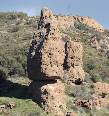
 Interesting rock on top of that cliff...

 Did aliens put that there?

 A close up...

 Trailhead for B/R???

Our destination today was Split Rock.  It felt like we hiked 2 miles already but between dogs and kids I honestly lost my timing.  We hiked down the B.R. trail for a moment and it lead out to an open field.  The trail continued to go lower but I knew this couldn't be right.  Here is another picture of:

 Balanced Rock

Of course I was wandering without my map which clearly states, "Balanced Rock".  It took Ayden to figure out at the time that B.R. stood for Balanced Rock.  Good job figuring that one out buddy.  Proud of you man...

 Yet another angle...

 Skull Rock

Way cool area, huh!
 
 Finally, cross into the Split Rock Camp!

 Cross the refreshing creek

 King of the Split

 Base Camp

We enjoyed PB&J sandwiches with crackers and lemonade.  A perfect Sunday afternoon adventure...

 Even Sammi ran through it...

A long hike back...

After our adventure we headed back up the PCH and exited at Hueneme Road.  From there, less than 5 miles to Chill Out Frozen Yogurt!  We deserved this treat and I ordered a Panini to go :)

Tuesday, January 29, 2013

Chill Out Hiking...


Day #796 - 801 * Hike #998 - 1003 * New Track #781 - 786
Sunday - Friday January 20 - 25, 2013
Chill Out in Port Hueneme, California


If you haven't seen my 40 second fame on the Rock Hill, South Carolina News Station, check it out:

 
To view my segment, scroll down to January 29th and search for 1000 Trails...
 
***Back to the hikes:


Business is going well.  Our only marketing strategy thus far comes from hiking around passing out fliers.  I often group back to Moranda Park and the Beach but the majority of these new tracks are by foot in the residential neighborhoods.  For entertainment purposes, I will share a few of the day time pictures under the sun...


Made the News in Rock Hill, South Carolina

Check it out:

Sunday, January 27, 2013

Top Hikes on the East Coast of the USA

Top Hikes on the East Coast of the USA
Florida, South Carolina, Alabama, Georgia, Ohio & Washington D.C.

Ratings:    Expert    Very Hard    Hard    Moderate     Easy    Very Easy

  1. Day 750: Canopy Walk - Myakka River State Park - Florida
  2. Day 747: Sewee Visitor Center - Nebo Trail - South Carolina
  3. Day 744: Brasstown Bald - Highest Peak in Georgia
  4. Day 744: Stone Mountain Park - Atlanta, Georgia
  5. Day 745: Sassafras Mountain - Highest Peak in South Carolina
  6. Day 750: Darling "Ding" Refuge - Sanibel, Florida
  7. Day 751: Clearwater Beach - Florida
  8. Day 747: Awendaw Passage of Palmetto Trail - Francis Marion National Forest, SC
  9. Day 749: Bill Baggs Florida State Park - Miami, Florida
  10. Day 751: Sawgrass Lake Park - St Petersburg
  11. Day 752 Pine Log State Forest - Florida's Panhandle
  12. Day 753: Cheaha State Park - Highest Peak in Alabama
  13. Day 751: Manatee Viewing Center - Tampa Bay, Florida
  14. Day 748: Manatee Island - Daytona Beach, Florida
  15. Day 745: Poinsette Bridge - Travlers Rest, South Carolina
  16. Day 745: Riverwalk - Rock Hill, South Carolina
  17. Day 750: Big Cypress National Reserve - Everglades - Florida
  18. Day 752: Britton Hill - Highest Peak in Florida
  19. Day 752: Panama City Beach - Florida
  20. Day 752: Florala State Park - Florala, Alabama
  21. Day 752: Vulcan Park - Birmingham, Alabama
  22. Day 747: Edison Nature Trail - Old Jacksonborough, South Carloina
  23. Day 749: South Beach - Miami Beach, Florida
  24. Day 752: Panhandle Pioneer Settlement - Florida
  25. Day 745: Oolenoy State Park - South Carolina
  26. Day 753: Talladega Superspeedway - Alabama
  27. Day 745: Lake Wylie-pitcarin - Tega Cay, South Carolina
  28. Day 746: Myrlte Beach - South Carolina
  29. Day 746: Glencairn Gardens-2012 - Rock Hill, SC
  30. Day 745: Manchester Meadows - Rock Hill, South Carolina
  31. Day 749: Fort Lauderdale, Florida
***Washington DC & Ohio will be updated at a later time...

Day 795: Channel Islands Harbor - Silver Strand, California - Captain Jack's Weather Stone - Battle Sails: Lady Washington vs Hwaiian Chieftain

Battle at Silver Strand

Day #795 * Hike #997 * New Track #779
Saturday January 19, 2013
Channel Islands Harbor - Silver Strand, California

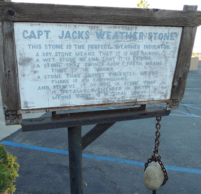
Captain Jack's Weather Stone
Battle Sails: Lady Washington vs Hwaiian  Chieftain
My Tripometer: 3 Hours * 3.5 Miles * +25 Feet


I began this hike in the Channel Islands Harbor, on the corner of Victoria and Channel Island Blvd.  It was mid afternoon and my quest for this mission was to hand out fliers and tag cars to introduce Chill Out Frozen Yogurt to the neighborhood. 


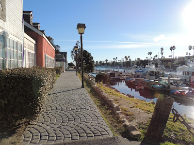
Other than a few cars in the parking lot, the area looked like a ghost town.  I walked down this nice sidewalk and the open court in between these building was completely vacant.  The Strand is only a few miles from our shop but the community may as well be a world away.  That said, we are still the closest FroYo shop to the Strand, and they ought to know!

 Looking back on my first quarter mile stretch...

 The channel was busy...

 Looking across Port Hueneme Naval Base...

Thats Boney Mountain in fhe far off distance.  Our shop is on the other side of the base.  The sidewalk from Channel Islands Harbor ended so I was forced out on to Victoria for a stretch before I reached the next walkway...


After tagging the cars, I continued my hike.  Maybe I should have walked the docks to hand out fliers?

 Dead end again; Maybe not?

 Closing in on the ocean...
 
The walkway ended again so it was back out to Victoria and then into the next lot...


This is why I hike.  To discover unique findings.  Who knew a stone was the perfect weather Indicator?


 Officially in Silver Strand


 A Pirate Ship on the Pacific!

 Topa Topa

 Silver Strand


 Anacapa

 Another Pirate Ship!

 They are in a Battle!

 Sunset


The sun is down, now I have to hike all the way back and then rendezvous with my wife to Chill Out:

Translate

ALEX'S LEMONADE STAND

ALEX'S LEMONADE STAND
Raising Money for Pediatric Cancer

RWANDA WATER HIKE

RWANDA WATER HIKE
Click Image to Learn More