Secret Waterfall (10 minute hike from the 101 Freeway in Newbury Park)
DAY 206: The Secret of the Arroyo
Date: Wednesday June 8, 2011
Miles: 1.25
Elevation Gain: 250 Feet
Time: 1 hour
Difficulty: No kids, No dogs, No people! Danger, Caution; If you go, you go at your own risk!
Reward: The most amazing rock formation and water system in the Arroyo Conejo!
Description: Beyond the "No Trespassing" sign, follow a cemented rock trail to the falls. The trail is easy until then, but if you wish to proceed further, be very careful and think twice about what you are doing!
Where: Newbury Park, CA
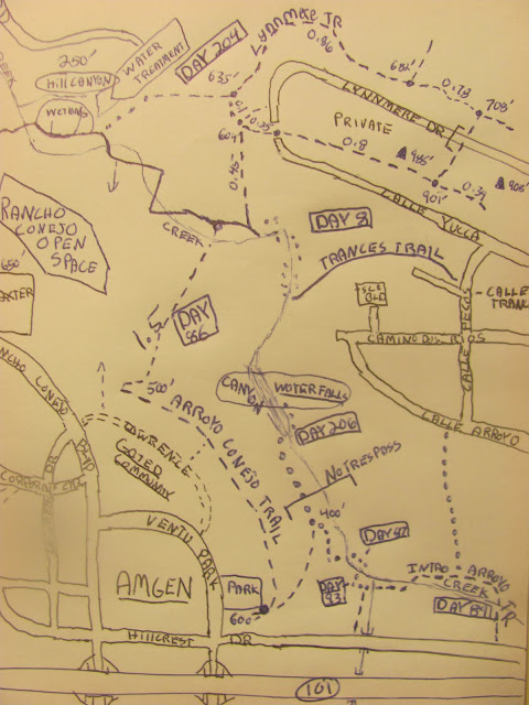
Directions:From the 101 Freeway in Thousand Oaks, exit on Ventu Park Rd. Drive north past Hillcrest and turn into the Conejo Ball Fields parking lot. For the first time, I am sharing my maps of the area:
Directions:From the 101 Freeway in Thousand Oaks, exit on Ventu Park Rd. Drive north past Hillcrest and turn into the Conejo Ball Fields parking lot. For the first time, I am sharing my maps of the area:
From the trailhead, take the downhill into the Arroyo
I must have missed this sign initially as I must have been chasing a bunny
The trail is easy at first
I was jogging but due to the cemented rock, the footsteps were a bit tricky
Looking back on the first waterfall system
A 5 minute walk from the neighborhood and I am awe inspired
It just keeps getting better, why is this offlimits?
There is no need to jump the creek; the trail is easy to follow
Say hello to the Howard the Duck Family; their from Cleveland I bet
Astonishing Rock Formations! Too bad so much graffiti.
Take the rope down to a private water tub; I passed on it
Are you kidding me!
Alert geologists, we've made a discovery!
Problem with off-limit places is; it attracts the thugles
From here, I had to jump the creek. No where to go but hurdling the rocks
The Reward!
**So, I ventured down here today to connect the dots on my map. I figured it would be one of those days where I wouldn't need a camera. However, it was so amazing that I could not let it go unpublished. It appears that the camera on my cheap phone works just fine, and it doesn't have the rain damaged blotches! It does restrict me with the zoom, but I think the photos came out quite well.
I understand why the city forbids people from coming down here. Once you reach the waterfall, it's quite dangerous. I challenged myself for a short while but then deemed that it was not worth it. I will try to climb upwards from the Lynnmere Trailhead on another day.
It's a damn shame that this natural Chumash Indian rock and river system was damaged by useless graffiti. Doesn't the city get it? If you restrict people from adventuring in an exciting area such as this, the thugles will come out and destroy history. You are far better off allowing the public to access a place like this and even pay for a ranger to help monitor the area. Construct rope and stairs to help the honest pass by and this privileged land will be enjoyed by all and stand the test of time. ***Bottom line, I love living in Ventura County. Over 200 days of hikes and i am still finding the amazing.
Hey, how bout those maps I've been promising? They are not to scale and I still have more trails to track north, but I feel good about them so here they are. Still not sure how to upload them as a pdf so for now, I snapped a picture and split the readable map in two. Click on it and print. Use your own best judgment if you attempt to conquer this land as I have and by reading this blog you can not hold me liable for you injury or anything else for that matter. Hey, have fun!
Arroyo Conejo (South of Wildwood)
West Rancho Conejo Open Space


yiicaang628kf
ReplyDeletegolden goose outlet
golden goose outlet
golden goose outlet
golden goose outlet
golden goose outlet
golden goose outlet
golden goose outlet
golden goose outlet
golden goose outlet
golden goose outlet