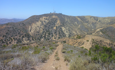
Two Trees from Above the V Loop
Day #622 * Hike #733 * New Track #609
Sunday July 29, 2012
Above the V Loop - Ventura, CA
My Tripometer: 45 Minutes * 1.75 Miles * +425 Feet
Trailhead
Directions:
From Downtown Ventura, take Catalina up to the very top of the hill and turn right on Hillcrest. Follow this higher and around and look for the trailhead on the right.
Earlier that morning we watched Alyssa and the Eagles win 4-0. She aided with an assist but it wasn't enough to take them to the tournament finals. Oh well...
I first visited this area on Day 587: Hike to the V, just a month ago. Follow the trail up and to the right. Pass the locked gate and you will soon reach a fork in the trail. Last time I took the right fork which lead directly to the V. Today, I went to the left...
The ground will swallow you :)
The V below
There is a faint fork in the trail here
I chose the main trail which takes you higher...
New views of the Back Country behind the Ventura Hills
Overlooking Ventura on this overcast day
Hall Canyon - I tried hiking this on Day 593: Hall Canyon
Due to the locked gate, I did not reach the back country
Let's go back this way...
My wife called and said that I would be taking the kids to Magic Mountain today. So, my hike was cut short. However, I noticed a lower trail on my way up so I hiked back down the hill and then proceeded lower along the trail in the picture above. This eventually lead back to the faint fork in the main trail just above the V.
With today's findings, I can easily plan two more hikes from this trailhead. First, I will follow the same high route in effort to reach Two Trees. Possibly I can locate a legit route to hike to the Hall Canyon Road which I believe will lead to Day 79: Sulpher Mountain Road.
I will then come back another time to hike the lower trail and then branch off to reach those radio towers. I believe that I should eventually run into Day 38: Serra Cross (The Cross).
Ventura: The best climate in the World!


This comment has been removed by the author.
ReplyDeleteHello, Did this hike today. We went up to the radio tower and then followed the road that went down toward the other direction. We estimated we would be about 3 miles away from the car and could hike the roads back to it. Unfortunately, after hiking all the way to where the road was we met a locked gate that was too high to climb and could not safely get around with our dog. So my friend got the bright idea to go down the hill and through some people’s backyard. Yes we had to go in their gate and right into their backyard. We quickly ran across the yard and out the other gate to the road. Thankfully nobody saw us. It was as estimated and was a short 3 more miles back to the car. Next time I would just turn around at the towers and just hike back on the trail. Again thank you for posting this hike on your website.
ReplyDelete