

by, Jeremy Jacobus
Monday, December 16, 2013
MYSTIC MOTH HOME PAGE (The Next 1000 Days...)
The Next 1000 Days never happened. But what did was...
Saturday, December 14, 2013
TOP 20 HIKES of ALL TIME
1. Days 976 - 978: Mineral King Loop Sequoia National Park - California
 |
| DAYS 976 - 978: MINERAL KING LOOP |
30.25 Miles +/- 8375 Feet
Mineral King may have been the hardest excursion I attempted, and accomplished, in my 1000 Day adventure. The physical requirements were challenging, but going this one all alone required intense mental stamina. Along the way you will pass more than a half dozen lakes. You will trek beyond the comfort of others. If you are looking for an escape to isolation, to test your will and courage, this journey is a must!
 |
| Days 998 - 1001: Mount Whitney |
Lone Pine - California
25 Miles +/- 7000 Feet
Climbing the Highest Peak in the Contiguous United States. Above 13,000 Feet I did get dizzy but with my team, we reached the summit! It took me exactly 1000 days to prepare for this moment; it was well worth it!
 |
| 3. Day 152: Green Sand Beach - Hawaii |
 |
| 4. Days 648 - 649: Santa Paula Punch Bowls |

 |
| 6. Day 83: Tangerine Falls |
 |
| 7. Day 929: Mt. Baldy |
 |
| 8. Day 576: Taft Point |
 |
| 9. Day 915: Matilija Falls |
 |
| 10. Day 418: Piedra Blanca |
 |
| 11. Day 216: La Jolla Valley |
 |
| 12. Day 852: Big Caliente Hot Springs - The Oasis |
 |
| 13. Day 250: Fryman Canyon - Los Angeles Rainforest |
 |
| 14. Day 750: Myakka River State Park |
 |
| 15. Days 504 - 509: Pacific Northwest |
 |
| 16. Day 243: Mary Jane Falls - Mt. Charleston |
Monday, November 25, 2013
Sunday, November 24, 2013
Saturday, November 23, 2013
Thursday, November 21, 2013
Wednesday, November 20, 2013
Sunday, September 8, 2013
Day 1000 - 1001: Descending Mount Whitney
 |
| Waterfall outside of Outpost Camp |
Day #1000 * Hike #1297 * New Track #999
Descending from the Mount Whitney Summit - Mount Whitney Trail
Monday August 12, 2013
My Tripometer: 4.25 Hours * 8.5 Miles * -4800 Feet +250 Feet
 |
| Daring Hikers take the Mountaineers Trail |
The bases of this being a "New Track" comes later when I hike down past trail camp in the day light to Lone Pine Lake. It was like a whole new track, hence the Waterfalls seen in the pic at the top of this post. We all heard the falls on our way up but the water system including Mirror Lake was invisible at the time.
After our hour pit stop at the top, we began our journey off the rock. To the right is an optional rugged trail, the Mountaineers Trail. It was marked by Cairns but we weren't about to follow these guys. Furthermore, according to the map it would not rejoin the Whitney Trail until after Lone Pine Lake (our destination for the night).
 |
| Backpacks at the John Muir Trail Junction |
 |
| Lakes below, we were dropping elevation fast to clear our heads! |
 |
| Heading down the switchbacks towards Trail Camp |
 |
| Fresh Water! |
This water was ice cold. If you look around on the mountainside there was still some left over snow drifts from last winter. If you are heading up, this water source will be your last chance to fill water en route to the summit. Ahhh, so fresh...
 |
| Marmots |
 |
| Meadows |
 |
| We were here in the dark, trying to beat the sun back |
 |
| Ah, Mirror Lake... |
 |
| The Trail |


 |
| Waterfalls just over Outpost Camp |
 |
| Passing Outpost Camp |
 |
| Following the stream towards Lone Pine Lake |
 |
| Lone Pine Lake in the near distance |
You can actually see this lake from the 97 switchbacks and it becomes more clear by Trail Camp but the trail swerves away before finally coming back to.

Day #1001 * Hike #1298 * Duplicate Track
Lone Pine Lake to Whitney Portal - Mount Whitney Trail
Tuesday August 13, 2013
My Tripometer: 1 Hour * 2.5 Miles * -1800 Feet +50 Feet
 |
| Rescue Units |
We camped Monday night at Lone Pine Lake. It was such a relief being back at 10000 Feet were the elevation was not sickening our heads. However, the elevation was not so kind to others.
We met a group before our accent and one lady did not acclimate well. Her group challenged themselves with the 22 mile day hike and one of their members separated from the pack. She accused one of her companions of trying to kill her?! She was completely delirious and ran off? She spent the night somewhere off the trail but was found early that morning. It was a could night and I could only imagine that she felt completely miserable.
Other than Adam forming some gnarly blisters on his feet from wearing bulky boots and heavy wool socks, our trip was a great success without injury or set back.
Well, this concludes my 1000 Hikes in 1000 Days. Only problem is that I can only account for 999 New Tracks. I did hike every single day for 1001 Days in a Row and by my count, I managed at least a mile per track on 1298 total adventures. That said, only 999 New Locations! Ugh, close enough...
***UPDATE:
It's been several weeks since Mt. Whitney. Wednesday August 14th was my hardest day. I lived it without setting foot on a trail! Strangely, I was not sore at all from Whitney. I walked normal this day and could have easily kept my streak alive. But, I think I pushed my family enough and I respected my wife's wishes by not going off on a hike that day.
I had many ideas of things to do for my next 1000 Days but elected to put everything on hold for 100 Days. Recently Ayden rejoined the VC Express Cross Country Team. Just as last year, I am volunteering to be a coach on the team. This means that I am jogging "hiking" on the Arroyo Verde Trails 4 times a week. So, I'm still getting out there; just not quite as much and not looking for new spots. Ahh, what a relief to some degree but honestly, I do miss the adventure.
Today was a FunRaiser for the club. I participated in the 2k run. It doesn't sound like much but when you add hills to the mix, it's anything but easy. I believe I finished about 10th in this easy competition. The better runs ran in the 3k and 5k. I clocked in at 11:47. This is a very slow time but I don't think I could have gone much faster. I'm still holding a weight of 220 pounds but hopefully by the end of the season I will cut some of that out. Of course, it doesn't help that I ate wings and drank beer at B-Dubs today. But it was the first full day of the NFL Season and as I write this, I'm watching the Cowboys game. I have Demarco Murray on my fantasy team, so let's go!
Ayden ran in the 2k event as well. He started off faster than me but I caught him on the big hill. He only finished 20 seconds behind me so good job little buddy!
***So what's next? Not sure. I still need my 1000th New Track so stayed tuned. I'll probably organize the blog a bit and figure something out. Any suggestions???
Friday, August 23, 2013
Day #1000: Climbing Mount Whitney! - Outpost Camp - Trail Camp - 97 Switchbacks - Whitney Summit
 |
| 14508 FEET - MT WHITNEY Supporting Alex's Lemonade Stand Foundation |
1000 HIKES
1000 DAYS
MOUNT WHITNEY
Day #1000 * Hike #1295 * New Track #997
Lone Pine Lake to Trail Camp - Mount Whitney Trail
Monday August 12, 2013
My Tripometer: 3 Hours * 3.75 Miles * +2200 Feet
 |
| Good Morning 4:00am from Lone Pine Lake |
Yesterday we hiked up to this camping spot to shed 2.5 miles (5 miles round trip) off the long day hike to the summit: Day 999: Whitney Portal to Lone Pine Lake. With the much lighter day packs strapped to our back and headlights on, Adam and I were first to leave the camp at 4:00am. Ian and Nick began their journey about 30 minutes later and eventually passed us...
 |
| Entering the Whitney Zone |
We were legit and all had permits to legally make this move. That said, we did not cross one ranger.
 |
| Outpost Camp - Elevation 10365 Feet |
 |
| ...And here comes Nick, with his shirt on... |
Don't be fooled by the brightness of the photo, the sun had still not lifted over the horizon. Where's Ian? He's coming...
 |
| Above the tree line into the meadows... |

 |
| Sun starting to shine it's light on the mountain ahead. |
 |
| Dawn |
 |
| Adam |
 |
| ...and the climb continues... |
 |
| Sunrise |
 |
| Here comes Ian |
 |
| Consultation Lake Elevation 11680 Feet |
 |
| Three Amigos |
 |
| Water Obsticle - no worries, trail goes Right around it |
 |
| Trail Camp ~12000 Feet |
 |
| Here I am all Bundled up |
 |
| Jimi's Tattoo - That's more like it |
 |
| Chipmunk |
At Trail Camp there were more than a dozen tents set up. This is a popular overnight spot and day hike break before climbing the infamous 97 Switchbacks! Like everyone else there, we filled up water from the glorified pond (no name small lake). If I had it to do over again, I would not have filled up here. Too much commotion, stagnant water, etc. Nearby Consultation Lake would have been a better spot but it's not easily accessible. However, a short way up the 97 switchbacks is an underground watering system. On our way down I snapped some shots of a good place to fill.
We rested nearly an hour here. Nick was long gone and we figured he blew right past this spot. There is no tree cover but with the cool morning temps, no big deal. I stripped off some layers, applied the 50 SPF and then chilled out a bit longer. I left a couple of sweaty shirts on some rocks to sun dry for pick up on my way back, Now that we were all recharged, Forward March....
Day #1000 * Hike #1296 * New Track #998
Trail Camp - 97 Switchback to Mount Whitney Summit - Mount Whitney Trail
Monday August 12, 2012
My Tripometer: 3.5 Hours * 4.75 Miles * +2750 Feet
 |
| Looking back down at Trail Camp |
 |
| 97 Switchbacks |
 |
| Marmots ruling the land |
 |
| Mice with no tails??? |
 |
| Easy grade, but long - Switchback after Switchback |
 |
| Starting to notice the elevation |
Dizziness over 13000 Feet. It was hitting Adam and I hard! At one point there was some doubt of our continuation. We slowed the slow pace, rested more often and I walked leaning toward the mountain as if I needed a V8, just in case I was going to faint.
 |
| The Cables |
 |
| Water Source - Icicles (there is a better place below to refill water but this is your very last chance) |
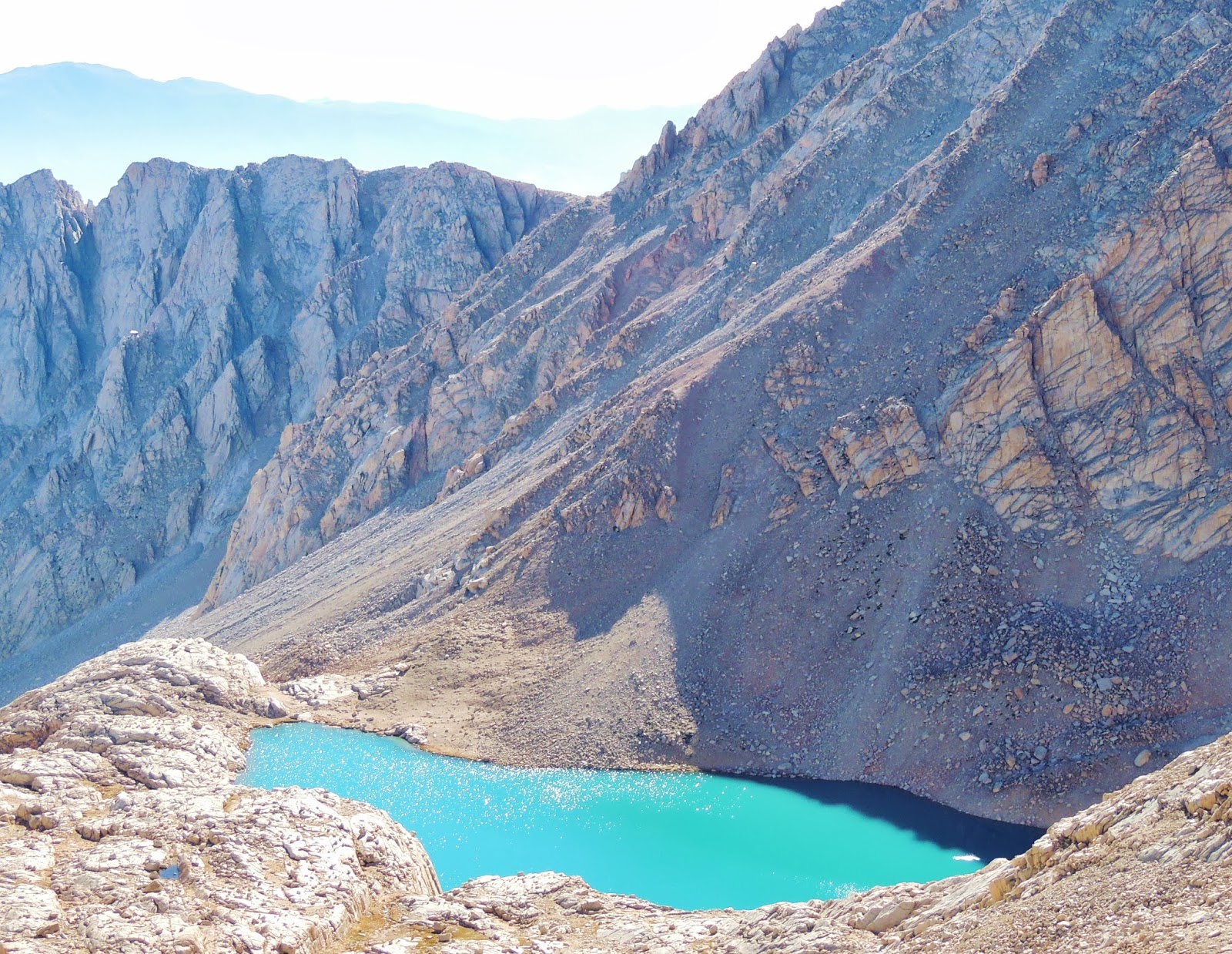 |
| Close up on Consultation Lake from high above |
 |
| Three more small lakes below |
 |
| Make that 5 or 6 Lakes... |
 |
| Trail Crest 13650 Feet - We Made it past the Switchbacks! |
 |
| The other side of the world - Hitchcock Lakes |
 |
| Entering Sequoia National Park - Guitar Lake below |
Fact, from the Whitney Portal, to drive to Sequoia National Park is 299 Miles. For us, 9 miles :)
 |
| In the distance (Franklin Pass?) |
 |
| Trail Junction, just 1.9 Miles to go 13484 Feet |
After Trail Crest you will lose a couple hundred feet of elevation. You may notice several heavy packs ditched off the trail here. I imagine these are the long haul hikers trekking the John Muir Trail or coming from Horseshoe Meadows. No sense lugging the big bags up since you'll have to just come back.
 |
| The final stretch |
This is anything but easy. It will take you at least an hour to complete this portion. There is a spot where you will lose some elevation before gaining it back again. What a drag. In the pic above, the peak on the left side of the picture is Mt. Whitney. It is not a straight shot...
 |
| This might be Arctic Lake below |
 |
| Close up, look up, you can see the shack on top of Whitney |
 |
| Watch your step |
 |
| Steep drop offs |
 |
| Around the final turn and finally, the summit is in sight! |
 |
| Inside the shack |
 |
| Century Home |
 |
| NO boom booms outside today - Perfect weather |
 |
| Whitney has grown several feet since this plaque was installed |
 |
| Ian and I were competing for the tallest living thing in the Contiguous United States |
What was so cool is that for a good few minutes, I stood taller than any living thing in the lower 48 states (standing on Solid Earth).
 |
| Resting my overweight hiking poles |
 |
| Views |
 |
| Nap Time |
I tried sleeping but fell short on breath. I could not rest comfortably. Nick said when he was up here, he took a long nap and some fellow hikers attempted to wake him but he did not immediate come too. Pretty scary. I reached the peak in under 4 hours and passed us by on his way down.
 |
| Over 10000 Feet above the high desert in Lone Pine |
This is the view of the canyon we hiked up and through to reach the summit. We are standing at the peak that you can easily see from the town of Lone Pine. Pretty magnificent!
 |
| Marmots posing for food |
Marmots and chipmunks swarm the top of Whitney. There are deep narrow crevices beneath the rocks on top in which they live and thrive. Keep an eye on your food because they will sneak up on you and snatch it...
We reached the summit at about 12:30 and hung out there for nearly an hour. We signed into the log book, ate some snacks and took some naps. But, it's not over yet. We still have to trek all the way back. Stay tuned for the completion...
Subscribe to:
Posts (Atom)
ALEX'S LEMONADE STAND

Raising Money for Pediatric Cancer
RWANDA WATER HIKE

Click Image to Learn More