
DAY 65: TRIUNFO CANYON TRAIL & BRIDGEGATE TRAIL
Miles: 6.0
Elevation Gain: 875 Feet
Elevation Gain: 875 Feet
Time: 1.25 Hours
Difficulty (1-10): 2.5
Reward (1-10): 1.5
Description: Follow me into the South Ranch section of the Los Robles. A shaded trail leads to an Edison Road. Bring your map because one wrong turn...
Description: Follow me into the South Ranch section of the Los Robles. A shaded trail leads to an Edison Road. Bring your map because one wrong turn...
Where?: Westlake Village, CA
Directions: From the 101 Freeway in Thousand Oaks, exit on Hampshire and drive south. Turn right on Triunfo Canyon Road and right on Tamarack St. Pass the first park entrance on your left and then at the end of the community park, turn left into the rear parking area. Park your car before the lot turns to the left.
**MY 65 DAY SUMMARY: 230 Miles +36,150 Feet**
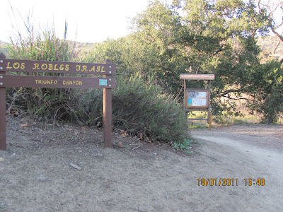
Walk up the hill and you will find the Trailhead
The Triunfo Canyon Trail leads you up a gentle incline underneath the shade of old oaks. In pursuit of the Los Robles Trail, you rise into the sagebrush and when you are high enough, there is a view looking back of Westlake Lake, I think. It was either that or the reservoir. The view is partially obtructed by the nearby hills and with the sun still going down early, I pushed up the trail quickly.
After a mile of uphill, I reached Edison Road/Los Robles Trail and turned left. You immediatately hit another junction and my plan was to take the low road (right fork). Trekking downhill a hundred fifty feet or so, you hear nothing! The valley below is vacant and the traffic of life is somewhere to be found. The 1.2 mile stretch was quick until you start climbing again. I admit, I slowed my jog into a swift uphill walk. Finally, I reached another junction known as White Horse. I turned left down the narrow trail but was very cautious with my footing. There is a lot of loose gravel initially on this steep introduction. The trail leveled out and then continue lower so I resumed my jogging pace. Halt! Breaks on! A narrow uphill junction intersects on the left. There is no sign but from what I remembered on the map, my intention was to go that direction. A quick 150 foot climb over 0.2 miles, I met another narrow junction. Hmm, I think I go right this time? I had made a total of three left turns and yeah, right seems right. Another quartermile up, I intersect another junction with sign posts! One post read, "White Horse Loop". That trail went to the right so I know that was wrong. However, the other post read "Equestrian Alternate". Hmm, i don't remember seeing that on the map, but maybe that was code for what I though was a road heading back to Brookview Ave. My plan was to hike a 4 mile loop and then walk the street a quarter mile back to the park.
I continued jogging with hesitance because I was very wary about my location. I was at a higher elevation and figured that by now, I would be able to see that body of water again. Instead, down below to the left was a housing track. Well, maybe that is Brookview.

Lake Sherwood Area
There was another trail leading back into the hills to the right so I decided to hand left and go lower for the sure thing. As the sun was setting and fearing that I was in the wrong spot, I picked up the downhill pace. As I came closer to these houses, I knew it had to be wrong. These homes were HUGE! Not that the homes in Westlake Village at million dollar worthy, but once up close to these guys, forget about it! At the bottom of the hill, the gate leading into the neighborhood was locked. I later found out by looking at the map in my car that this trail was known as the Bridgegate Trail. According to the map, there is no trailhead but if you keep going beyond the neighborhood, it will lead out to Potrero. But not before:


After crossing the creek area, I finally accepted where I was. I did not actually see the Lake at Lake Sherwood, but I assumed that the water way lead to it; I wasn't about to explore. I wasn't certain which direction to go but I assumed left. Fretting that I was 5 miles+ from my car, I began jogging the streets. I used my experience in the 26.2 mile LA Marathon last year to aid my legs to keep motion. I approached Westlake Blvd. and made a left. I kept chugging along and then crossed an aqueduct. I snapped a picture and you can view it on Facebook. If nothing else, I found another place to hike :)
I felt reassured when I came upon Triunfo Canyon Road. I turned left and picked up my running speed until I reached the park. Using Google Maps, I determined that I only ran 2 miles in the streets. Not too bad! Below is a sideways view map of the area that I covered. I hadn't been in the Los Robles Trail area since Day 24. There are still many trails to cover and I will be back to South Ranch before my 1000 days is complete.


fhyu59fgsh
ReplyDeletegolden goose outlet
golden goose outlet
golden goose outlet
golden goose outlet
golden goose outlet
golden goose outlet
supreme outlet
golden goose outlet
golden goose outlet
golden goose outlet