 |
| A Bike Ride in Houston |
Sunday March 27, 2016
8.51 Miles * +/-483 Feet
- Lee & Joe Jamail Skate Park - Buffalo Bayou Walk
- Angelina National Forest:
- Boykin Springs
- Jackson Hill Marina - Sam Rayburn Lake
- Big Thicket National Reserve
- Pitcher Plant Trail - Turkey Creek Trail
- Sundew Trail
- Beaumont, Texas
- Gerald D Hines Waterwall
Lee & Joe Jamail Skate Park - Buffalo Bayou Walk
 |
| Lee & Joe Jamail Skate Park |
**Arriving at the Lee & Joe Jamail Skate Park was our last destination of the day but it was the most rewarding, thus begin my 13th Day Course with this adventure:
RAN 6.05 MI ON 3/27/2016
DISTANCE
6.06
miles
CLIMB
*350 ft
- BEGINS IN:
- Houston, TX, United States
- CREATED BY:
- Jeremy Jacobus Best Time: 1:32:44
- DESCRIPTION:
- This is a 6.06 mi route in Houston, TX, United States. The route has a total ascent of 181.92 ft and has a maximum elevation of 129.3 ft. This route was created byJeremy85135177 on 03/27/2016. View other maps that Jeremy85135177 has done or find similar maps.
- TYPE:
- Run
 |
| Buffalo Bayou Walk |
After rounding this first section we noticed several bikes pass us by and a map. We followed it back up, across the street from our RV where we slid the credit card and rented three bikes for $5 each. This allowed us to follow the entire mapped river area in just under an hour...
It was soon nightfall and back on the road. Next stop, Corpus Christie...
Earlier that day:
Angelina National Forest - Jackson Hill Marina
RAN 0.31 MI ON 3/27/2016
DISTANCE
0.31
miles
CLIMB
*40 ft
- BEGINS IN:
- CREATED BY:
- Jeremy Jacobus Best Time: 09:43
- DESCRIPTION:
- This is a 0.31 mi route in . The route has a total ascent of 1.05 ft and has a maximum elevation of 209.35 ft. This route was created by Jeremy85135177 on 03/27/2016.View other maps that Jeremy85135177 has done or find similar maps.
- TYPE:
- Run
 |
| Jackson Hill Marina |
-After Ziplining the night before, we rolled out through the darkness for about an hour and landed at the Jackson Hill Marina located in the Angelina National Forest. After being up for practically two days straight, this rest was well deserved...
I didn't hike much in here. We basically overslept by two hours which put us behind schedule for things that I did want to do today. Next stop, Boykin Springs, located within the Angelina Forest...
The picture above is all we got for Boykin Springs. The dirt road was an alternate choice which lead to a free campground area with no water or facilities. We were pointed this way by the forest ranger who guarded off the road into Boykin. I guess there were heavy rains the week before which washed away the road. It would have been nice for a sign to be posted off the main highway.
Big Thicket National Reserve: Pitcher Plant Trail
 |
| Pitcher Plant or Turkey Creek Trailhead? |
RAN 0.31 MI ON 3/27/2016
DISTANCE
0.31
miles
CLIMB
*30 ft
- BEGINS IN:
- CREATED BY:
- Jeremy Jacobus Best Time: 06:33
- DESCRIPTION:
- This is a 0.31 mi route in . The route has a total ascent of 0.76 ft and has a maximum elevation of 186.38 ft. This route was created by Jeremy85135177 on 03/27/2016.View other maps that Jeremy85135177 has done or find similar maps.
- TYPE:
- Run
Mission Failed! First, I wasn't sure which way to go (see sign below). Off the main highway we drove a few miles down F.M. 1943 and found this sign. I turned into the parking loop, turned back, continued down the road to another sign which said Pitcher Plant. I then began driving down the dirt road, which you are not supposed to do in this RV, so we turned back. The Visitor Center was 10 miles south of here, and we were coming in from the North. So rather than back tracking, we began our hike from here...
Around the first turn, the trail was stupid muddy and flooded. There was a sign that said, "Boardwalk may be Slippery when Wet", but the area look blah, so we passed...
Big Thicket National Reserve: Sundew Trail
RAN 0.65 MI ON 3/27/2016
DISTANCE
0.66
miles
CLIMB
*32 ft
- BEGINS IN:
- CREATED BY:
- Jeremy Jacobus Best Time: 13:53
- DESCRIPTION:
- This is a 0.66 mi route in . The route has a total ascent of 7.08 ft and has a maximum elevation of 158.76 ft. This route was created by Jeremy85135177 on 03/27/2016.View other maps that Jeremy85135177 has done or find similar maps.
- TYPE:
- Run
This trail worked out fine. Easy boardwalk, interesting plant life. There was another loop trail that was on dirt, which we could have taken - didn't appear muddy, but instead we pressed forward to Beaumont, Texas...
Pretty flowers in the median of the highway. Later in this trip these flowers really came to life. That post will be upcoming...
Beaumont, Texas
 |
| Easter Sunday in Beaumont |
Welcome to Houston...
Home of the 2016 Final Four? I didn't know, nor would it have made any difference. As I write this post, the National Championship Game is actually on tonight, I believe. I basically stopped following the tourney when Xavier and Bill Murray were eliminated. I discussed this on a previous post.
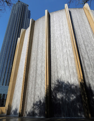
Gerald D Hines Waterwall
2800 Post Oak Blvd.
Houston, TX
 |
| Waterwall - Amazing! |
RAN 1.18 MI ON 3/27/2016
DISTANCE
1.18
miles
CLIMB
31 ft
- BEGINS IN:
- Bellaire, TX, United States
- CREATED BY:
- Jeremy Jacobus Best Time: 46:43
- DESCRIPTION:
- This is a 1.18 mi route in Bellaire, TX, United States. The route has a total ascent of 31.87 ft and has a maximum elevation of 130.09 ft. This route was created byJeremy85135177 on 03/27/2016. View other maps that Jeremy85135177 has done or find similar maps.
- TYPE:
- Run
I can imagine on a Hot Humid Houston Summer Day, this place would be packed. Reminds me of Millennium Park in Chicago.
Located in this area is the Houston Galleria, but we did not step inside. It's said to be one of the must see places in Houston, Perhaps next time...
Prior to arriving at Post Oak, Jess took a class at Orange Theory while Ayden and I played Dominos. Not sure how we were able to squeeze all of this into one day, but we did...
-And so the RV Trip shall continue...


No comments:
Post a Comment