
 |
| Getty Up! |
14th Course: Corpus Christi & San Antonio
Monday March 28, 2016
7.44 Miles * +/- 122 Feet (Elevation in this area is hard to find)
- Corpus Christi
- Horseback Riding - South Padre Island
- Harbor Bridge - USS Lexington
- San Antonio
- KOA Campground
- Riverwalk - The Alamo
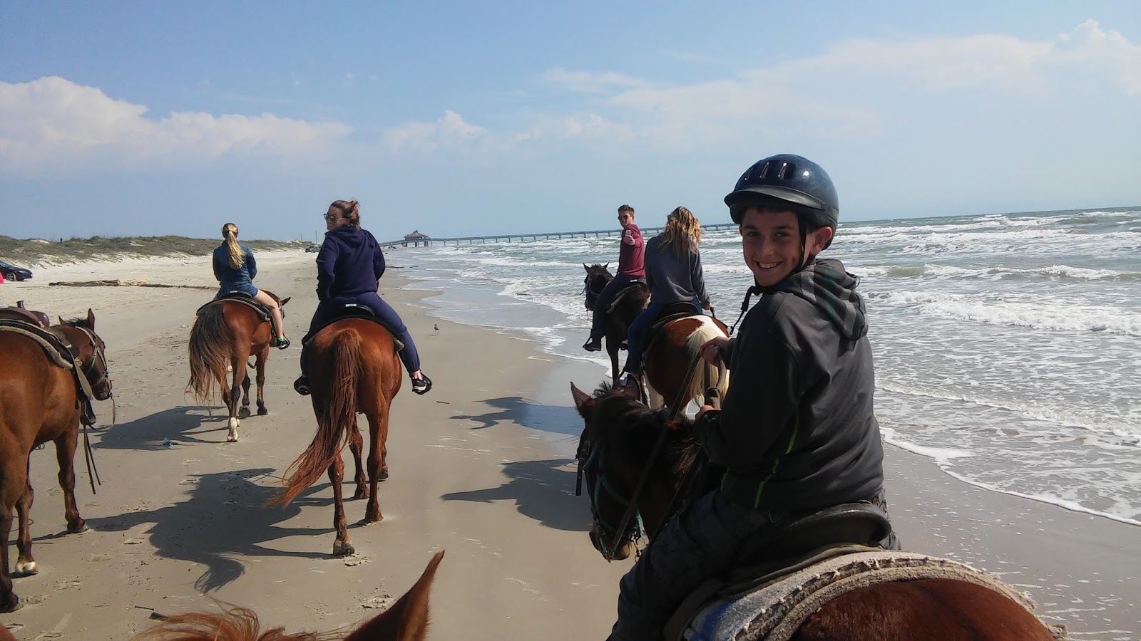
Horsebacking in Corpus Christi - South Padre Island
 |
| Yee-Haw! |
Horse Back 3.14 MI ON 3/28/2016
DISTANCE
3.15
miles
CLIMB
55 ft
- CREATED BY:
- Jeremy Jacobus Best Time: 1:15:22
- DESCRIPTION:
- This is a 3.15 mi route in . The route has a total ascent of 55.43 ft and has a maximum elevation of 19.69 ft. This route was created by Jeremy85135177 on 03/28/2016.View other maps that Jeremy85135177 has done or find similar maps.


 |
| Saddle Up |
 |
| Take it to the Beach |


This was only my 2nd, perhaps 3rd time riding - and I now feel like a pro! The last time I rode was on a Mountain Trail, climbing some 1000+ Feet. I felt discomfort with that, especially going down. On the way up, I could feel my horse sweat and I felt wrong with my 200+ pound ass on him.
Today, it was a Breeze of Cake. However, not all were as lucky. After a brief drizzle, the sky cleared up which made it a most enjoyable ride. No issues until after we turned around to head back. The trainers did say that the horses became more excited knowing that they were heading back to the stables. The next event was unexpected. One of the rear trainers decided to gallop up towards the front. At the time, I was riding comfortably in the middle. As she passed, she spooked the horse directly behind me which jolted her off stride. I witnessed the 5 second chain reaction event in slow motion...
The fret on the ladies face charged up and beside me. My horse reacted, took off like a champ and perhaps attempted to buck me. At that same time, another lady on a different horse surged quickly to the water. Her voice of fright was on echo delay as myself and the first lady calmed the storm and settled our horses. I grabbed solid control and command - fortunately I did not have the phone out taking pictures at the time, although if I did, you would have seen this:
The last ladies horse stampeded into the water, circled back and faced a log obstacle forcing it to jump. The older woman wearing glasses completely panicked and had no control. In mid air at max height, she let go and fell hard into the gulf water on her hip. The waves came crashing over her as she cried there on her back.
The situation could have been worse as the loose horse circled the group. My boy was still at unrest and wanted to play catch-up. The other horses as well were startled, but all grabbed hold. My wife and son did well, escaped the panic and terror.
One point here, the lady who did fall had to use a stepping platform to mount her horse. In my opinion, if you are unable to jump on yourself then perhaps you should not ride. Keep in mind that this is an animal and instincts of such are quite possible and uncontrollable. As for me, I did have a guiding hand mounting up, but control is not actually that much different versus riding my motorcycle at 100 mph+; a daily routine - a life saver perhaps in this case...
Harbor Bridge - Corpus Christi
 |
| Harbor Bridge - Corpus Christi |

**After the long day in Houston (the night before the horses), we arrived late in Corpus Christi. This plan was executed brilliantly - See the amazing Harbor Bridge lights and then sleep under it's dazzle!

Of course, rather than just look at it through the windows of the RV, why not go for a hike? Albeit, it wasn't a very long walkabout, Ayden and I took steps while Jess got ready for bed...


We then drove across the bridge where we would then settle near the USS Lexington...


 |
| Good Night... |
USS Lexington - Corpus Christi
 |
Walk 0.83 MI ON 3/28/2016
DISTANCE
0.83
miles
CLIMB
9 ft
- BEGINS IN:
- Corpus Christi, TX, United States
- CREATED BY:
- Jeremy Jacobus Best Time: 25:12
- DESCRIPTION:
- This is a 0.83 mi route in Corpus Christi, TX, United States. The route has a total ascent of 9.57 ft and has a maximum elevation of 16.17 ft. This route was created byJeremy85135177 on 03/28/2016. View other maps that Jeremy85135177 has done or find similar maps.
 |
| Good Morning! |


The Map above suggests that we were walking on water... No, this isn't Magic as sung by the Cars in the mid 80's, but this is Ayden and I being us while Jess watches from afar...


After the morning walk through - not much happening at this hour - we drove the 30 minutes to the Island, to ride horses -- and from there, the day would then continue on to:
San Antonio: KOA Campground
 |
| Dog! |
Hike 1.09 MI ON 3/28/2016
DISTANCE
1.09
miles
CLIMB
7 ft
- BEGINS IN:
- Kirby, TX, United States
- CREATED BY:
- Jeremy Jacobus Best Time: 30:37
- DESCRIPTION:
- This is a 1.09 mi route in Kirby, TX, United States. The route has a total ascent of 7.31 ft and has a maximum elevation of 636.81 ft. This route was created byJeremy85135177 on 03/28/2016. View other maps that Jeremy85135177 has done or find similar maps.

Between Corp Christi and San Antonio I had though about venturing off to explore for Steve Austin. Based on the information that I had, he lives on a property, without an address, along the Nueces River, approximate 15 miles Southwest of the town of Tilden, which is roughly an hour and a half south of San Antone. The detour to drive though the area may not have been long, but to scout out the entire area would have been a day full event.
Instead, arriving mid-afternoon at the campground, a place to recuperate, Ayden and I took a dip in the pool while Jess Chillaxed! Then, while the family rested up and freshened up, I explored around the grounds...


There was a bike path, perhaps it went somewhere special. However, and instead, we hopped a city bus, passed the AT&T Center where the Spurs play, and landed at:
San Antonio: Riverwalk & The Alamo
 |
| Riverwalk |
Riverwalk 2.37 MI ON 3/28/2016
DISTANCE
2.37
miles
CLIMB
51 ft
- BEGINS IN:
- San Antonio, TX, United States
- CREATED BY:
- Jeremy Jacobus Best Time: 1:29:57
- DESCRIPTION:
- This is a 2.37 mi route in San Antonio, TX, United States. The route has a total ascent of 51.44 ft and has a maximum elevation of 695.34 ft. This route was created by Jeremy85135177 on 03/28/2016. View other maps that Jeremy85135177 has done or find similar maps.

Ever since the Cavs played the Spurs in the 2008 Final, and got swept of course, I've been wanting to visit this place. They made it look so amazing on TV, and it did not disappoint in reality. We arrived around the dinner hour, found a nice spot to eat and then walked into the dark night. At times we ramped up from the river to explore, including the discovery of:
 |
| The Alamo! |


Our carriage awaits. Hop on board - back to the campgrounds for a good nights rest... Okay, so we hopped the bus back, but one can only imagine..
-How the Southwest was Won!


No comments:
Post a Comment