Sunday, October 28, 2012

Day 704: Los Angeles River - Pedlow Field Skate Park - Sepulveda Basin Off-Leash Dog Park - Sepulveda Dam - U.S. Army

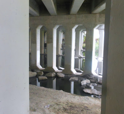
The Los Angeles River, under Balboa Blvd.

Day #704 * Hike #851 * New Track #684
Saturday October 20, 2012
Los Angeles River - Van Nuys, CA
Pedlow Field Skate Park
Sepulveda Basin Off-Leash Dog Park
Sepulveda Dam - U.S. Army
My Tripometer: 1.5 Hours * 3.25 Miles * +50 Feet
 
Directions:
From the 101 Freeway near the 405 interchange, exit on Balboa and head north.  About a half mile up on the left you will see a large Park and Ride parking lot on the left.  This is just before crossing the L.A. River.
 
Ayden and I had just toured Balboa Lake and our intention was to head back home.  However, when I didn't realize that the LA River was right here and when I saw an opportunity to park, we took it.
 
We jumped on our bikes and went under the Balboa Tunnel.  However, the bike path seemed to just head back over to the park we were just at so we turned back around and pedaled west...
 
 Soccer Sand Lot...

This was an easy bike ride and we followed the bike path along a street up to White Oak.  We turned right and tried going through a park but after reaching the baseball fields we were forced back out.  We hiked a bit here and then mounted our bikes to cross the river...

 Crossing the L.A. River on White Oak

The park that you see on the other side of the river is the Sepulveda Basin Off-Leash Dog Park.  We ditched the bikes and hiked around here for a bit.  Essentially, the dog park is on the corner of White Oak and Victory.

After a short visit, we pedaled down Victory and found the coolest skate park ever...

 Pedlow Skate Park


 Ayden did not participate on his mountain bike...

 Barbed Wire around the Sepulveda Dam Reservoir Area

 
This was a neat, easy hike and bike.  We walked a mile and biked a couple more.  The weather all day has been overcast - perfect!
 

Day 704: Anthony C. Beilenson Park - Lake Balboa

Waterfall at Balboa Lake

Day #704 * Hike #850 * New Track #683
Saturday October 20, 2012
Anthony C. Beilenson Park - Lake Balboa, CA
Woodley Lakes Golf Course - Bull Creek
My Tripometer: 1.5 Hours * 3.75 Miles * +100 Feet
 
 Awesome Playground!

Directions:
FREE PARKING!!!  From the 101 Freeway near the 405 Interchange, exit on Balboa and drive north for about a mile.  The park entrance will be on your right.

 Let's take a bike ride around the lake

 Is this The Barry Sanders?  Looks like a kickball court...

 Wandering around on foot...

 Our chariot awaits us!

 Woodley Lakes Golf Course...

 Ayden caught a fish with his bare hands!

 Crossing Bull Creek

We rode around and hiked back here...
 
This is the second time that I discovered amazing nature life right next to the busiest freeway intersections in the world!  Lake Balboa is a vast area.  Plenty of people grilling lunch on the barbie, kids playing, bikes riding, even a small sail boat?  People fishing, waterfalls, hiking, running, kites -- where am I; Yosemite?  Awesome spot.  I'm glad we found it!

Day 704: Saddletree Ranch - Stetson Ranch Park

Don't slip or you will become a Plinco piece from the Price is Right!

Day #704 * Hike #849 * New Track #682
Saturday October 20, 2012
Saddletree Ranch - Sylmar, CA
Stetson Ranch Park
My Tripometer: 1 Hour * 2.5 Miles * +100 Feet
 
 Saddletree Ranch Trailhead at Glenoaks Blvd.

 The horse trail heading west...

The trail also went back to the east and I assumed that the eastward trail would have met up with Wilson Canyon Park where we were at earlier.  So, Ayden and I began to pedal down this horse route to the west.  About a quarter mile late, we ended up at some stables and a dead end.  We turned back and then drove around looking for a legit place to hike or bike...  This was not considered a hike because it was too short and no actual hiking!

 Open Space Trailhead Found!!!

Where Balboa Blvd crosses the I-5 to the north, wrapping above the 210 freeway, we turned down Silver Oaks.  The street had some industrial buildings including MB2, an indoor go kart track.  We have one of these in Newbury Park but told Ayden that it was closed.  Gullible boy, he believed me.  A bit further down Silver Oaks, the street kind of ends, but not really.  It looks like they will be building homes out here eventually.  The street was paved and we took it to this open space.


 Ayden jumping over the ditch!

Open Space...
 
We came in through a difficult part therefore we did not bring our bikes.  We ended up looping back around this road and if I would have known it was there, I would have taken the bikes back out to explore further.  This seems like an interesting area to explore and if I lived up this way, I would be stomping through it.  However, as a tourist it's not that groovy so we decided to head back to the car to look for another spot...

Day 704: Wilson Canyon Park - In the Rim of the Valley Trail Corridor - Los Pinetos Trail - Wilson Dam

Wilson Dam

Day #704 * Hike #848 * New Track #681
Saturday October 20, 2012
Wilson Canyon Park - Sylmar, CA
In the Rim of the Valley Trail Corridor
Los Pinetos Trail - Wilson Dam
My Tripometer: 2 Hours * 3.5 Miles * +550 Feet
 
 Wilson Canyon Park (notice the fee box to the right)

Directions:
Jump on the 210 Freeway East from the 5 and take the 2nd exit on Roxford Street.  Turn left to go under the freeway and then follow the road to the right (Olive View Drive).  Drive down about a mile.  Turn left when you see the park entrance as shown in the picture above.  Follow this road all the way up the hill.  There will be a fork up there, we turned left and parked in a large, empty gravel lot.

 Trailhead

 Looks like a legit trail straight ahead...

Ayden could not pedal on this thick sand so we turned back.  From the trailhead, you will reach an intersection.  Essentially, we turned left which will wrap you around Wilson Dam.  I suppose the dirt road we were on is considered the In the Rim of the Valley Trail.

 Nice horsey!

 Cool shaded picnic area

 Looks like we are on the Pinetos Trail.  We continued straight...

 We turned left up this steep dirt path

The trail conditions for mountain biking were horrible!  The sand was so thick!!  This is good for horses but no good for bikes.  We walked this entire hill and overall, we probably hiked about half of this entire track...

 We finally made it to a nicer road, still quite sandy though

The right seemed like it would lead you into an interesting area of wilderness but at this point, Ayden was quite frustrated.  Thus, we turned left and ended up walking our bikes.  We ditched the bikes for a bit because we could see across the dam and noticed a white vehicle parked next to our car.  We hiked to try to gain a better vantage point but by then, the car was gone.  There are many side trails to explore here.  Thankfully it was not hot today because this area would likely be brutal in the summer and the reward is very minimal...

 More uphill walking...

 rejoining civilization

We made a loop out of it.  Shortly after this snapshot we encountered a hospital and a paved road.  We were able to pedal again up the road, past the dam and back to the car.  Once there, this is what I found...

Seriously!!!
 
At the entrance of the park is a drop box to pay $5.00 for parking.  I did not notice this when driving in to the park so on my way out I donated $5.00 for our enjoyable experience!  I will contest this ticket and hopefully they'll let this ridiculous $70.00 go...

Friday, October 26, 2012

Day 704: O'Melvany Park - Grotto Trail - Granada Hills

Derby Junk Cars - Seen from the Grotto Trail

Day #704 * Hike #847 * New Track #680
Saturday October 20, 2012
O'Melvany Park - The Grotto Trail - Granada Hills, CA
My Tripometer: 3 Hours * 4.5 Miles * +850 Feet
 
 Good Morning...

Directions:
From the I-5 heading south from Santa Clarita, take the San Fernando Road and Balboa exit.  If you are not careful you can easily pass this like I did!  It's just after the 14 and just before the 210.  Note, you cannot reach this exit coming from the south.  I know because I tried.  I should have jumped on the 118 to scoot back over to the west but I was just all confused and didn't have my morning coffee, nor did I have GPS...

Anyhow, if you exit on San Fernando, follow this to Balboa and turn right.  Then turn right on Sesnon and that will lead you to the park...

 Foggy Walk-Thru...

 Off the race course, a trail to explore some other time?

 The Grotto Trailhead

After spending 30+ minutes on the walk thru, looping around the 1.8 mile course, I split away from Ayden and made my way back to this trail...

 It goes back there and climbs!

 A split to the left, but I kept straight...

 Looking back, where am I?

This is quite a steep climb and I wasn't really prepared for it.  Running the trail was out of the question.  I marched up about 3/4's of a mile and nearly 700 feet by my best guestimation.  I heard the gun go off for the first race but kept going.  The sound of the cheering became faint and my visibility wasn't much brighter than that up here.  Finally, I turned back and heard the next gun shot go off for the next race.  Knowing that Ayden would be running soon, I raced back and warmed up the bantam boys for their race...

 Ayden running on his first lap

His asthma limited his breathing.  Whenever this kind of weather sneaks up on us, Ayden can't breath very well.  He finished the run but it wasn't pretty...

The Nature Trail
 
We left the course shortly after Ayden completed his run.  Meanwhile, the midgets and youths were still competing.  Although Ayden wasn't feeling great, we had a big day ahead of us...

Day 699 - 703: Hiking in Ventura...

Overlooking the Northend of the Avenue

Day #699 * Hike #842 * New Track #679
Monday October 15, 2012
Shoshone Trail - Ventura, CA
My Tripometer: 30 minutes * 1.5 Miles * +125 Feet
 
 Trailhead

Directions:
From the 33 Freeway in Ventura, exit on Stanley and head over to Ventura Ave.  Turn left up the Avenue and then turn right on Shoshone.  Take Shoshone to the end and park on Cedar.  Technically, this is trespassing up here.  I actually walked from Deanza School and found this trail...
 It was an unexpected nice walk

 The trail was legit!

 It switchbacks even higher!

 Multiple ways to go up here...

One way, I forget which now, lead to a private residence.  Not sure where the other way would have taken me.  Ayden and I skipped cross country today to hang out with Alyssa.  In a couple days from now, she would be entering the hospital for a surgery and required to stay for a week.  This all stems back from her broken arm on St. Patty's day.  I wonder if that girl ever thinks about how she kicked Alyssa in the leg to make her fall.  I know she has no clue of the difficulty that Alyssa is still going through.  ---

Back down to the bottom...
 
There are other hills to climb in the area.  I once hiked the Avenue Trail to DeAnza.  There are many homeless people living behind the school, pretty scary huh!  I didn't go that way today.  Instead, I explored and found this.  Well, now that I got my hike over with, it was off to the beach with the kids.  This time, I actually just hung out at the beach so no hike for me there...
 
Day #700 * Hike #843 * Duplicate Track
Tuesday October 16, 2012
Arroyo Verde - Ventura, CA
My Tripometer: 1.5 hours * 2.5 Miles * +250 Feet
 
I made it to 700 days!  Back at cross country practice and it wasn't easy for me.  It never is.  I always try to run with my all and gradually I've been losing weight.  I am 3 weeks behind now on New Tracks.  With just 300 Days to go, I'm going to need to find a way to narrow that gap!
 
Day #701 * Hike #844 * Duplicate Track
Wednesday October 17, 2012
Kimball Park - Ventura, CA
My Tripometer: 45 minutes * 4 Miles * +75 Feet
 
I jogged a there - back - there to complete the 3.75 mile run.  I didn't time myself for this.  Okay, so I walked a little too.  On top of everything, my shin splints will not go away.  On most days, they hurt my than my sciatic nerve.  Ugh, it sucks getting old!
 
Day #702 * Hike #845 * Duplicate Track
Thursday October 18, 2012
Camino Real - Ventura, CA
My Tripometer: 1 Hour * 2 Miles * +25 Feet
 
The middle schoolers were having a cross country meet and our head coach of the VC Express basically organized it for them.  It's been a while since I ran around Camino Real, but it is still a duplicate for me.  After counting 145 kids, I ran in the back as a sweeper.  This is the first time I actually ran during a live race!  Maybe one day I will be fast enough to be the Rabbit!  Nah, not likely.  Another coach on our team often rabbits races.  He went to Chico State and in his real running days, he would run 130 miles a week.  And yeah, he destroys me at practice too and doesn't even sweat doing it.  At some point, genetics determines the runner.  Not to say that hard work doesn't pay off because even if you have the DNA code, you still have to fight your way to find your true ability.  I give coach all the credit for finding himself and the commitment that he took to become a great runner.  For me - well, I'm a lazy hiker who just happens to run occasionally.  By the way, I broke the rules of sweeper.  I couldn't stand the slow turtle pace so I ended up passing 30 or so slow runners and run at the back of the main pack...
 
Day #703 * Hike #846 * Duplicate Track
Friday October 19, 2012
Arroyo Verde - Ventura, CA
My Tripometer: 1 Hour * 3 Miles * +350 Feet
 
This was a jog with Sammi in the hills.  I enjoyed a few beers when I was done.  A big weekend to come...

Translate

ALEX'S LEMONADE STAND

ALEX'S LEMONADE STAND
Raising Money for Pediatric Cancer

RWANDA WATER HIKE

RWANDA WATER HIKE
Click Image to Learn More