Mount Whitney and the Big Whitney Meadows from Cotton Pass
(You have to earn your right to appreciate this view of Whitney)
Day #577 * Hike #669 * New Track #572
Thursday June 14, 2012
Horseshoe Meadows Campground - Lone Pine, CA
My Tripometer: 1 Hour * 1 Mile * +25 Feet
**Before you comment about the mileage and distance, please read on for the 2nd Hike...
Spectacular views drving up Horseshoe Meadows Road
Directions:
From Los Angeles, California, take the I-5 North to the 14 North to the 395 North and then turn left on Whitney Portal Road (the only traffic light in the town of Lone Pine). A few miles up just past the Alabama Hills turn left on Horseshoe Meadows Road. Take this up all the way to 10,000 feet and it will end at the campgrounds...
Here we go...
Continue straight to Cottonwood Pass
The campgrounds is a Walk In and Self Pay site for only $6 a night. Basically park your car, pick your spot and enjoy. Ayden and I arrived early enough to scout out the perfect spot. There are only 24 sites and they do not take reservations. That said, there is so much open space up here that if the grounds were full I don't see any reason why you couldn't just put a tent anywhere to stay the night. Fires are allowed but the instructions state to bring your own wood. Fortunatly I had this well planned out and we brought our own wood.
Ayden was very scared of Bears. The bear canisters were foreign to us and the thought of them were intemidating. However, I will tell you that after this experience I feel much more comfortable with bears; maybe because I did not see any.
After finally scoping out the grounds, debating (arguing) of where to set up camp, we (I) made ten or so trips from my car to the site. We brought a cooler and many blankets and pillows in preparation for the anticipated cold night ahead. The day time temp in Lone Pine was well over 90 but it felt like a perfect 72 at 10,000 feet. The lows in he forecasted were suggested to dip as low as 25 degrees. So, unlike dry camping where you hike in, the 150 foot back and forth made it easy to bring comfort to the night. Now that I accumulated a mile+ around the campgrounds and the tent is set, let's go for a real hike!
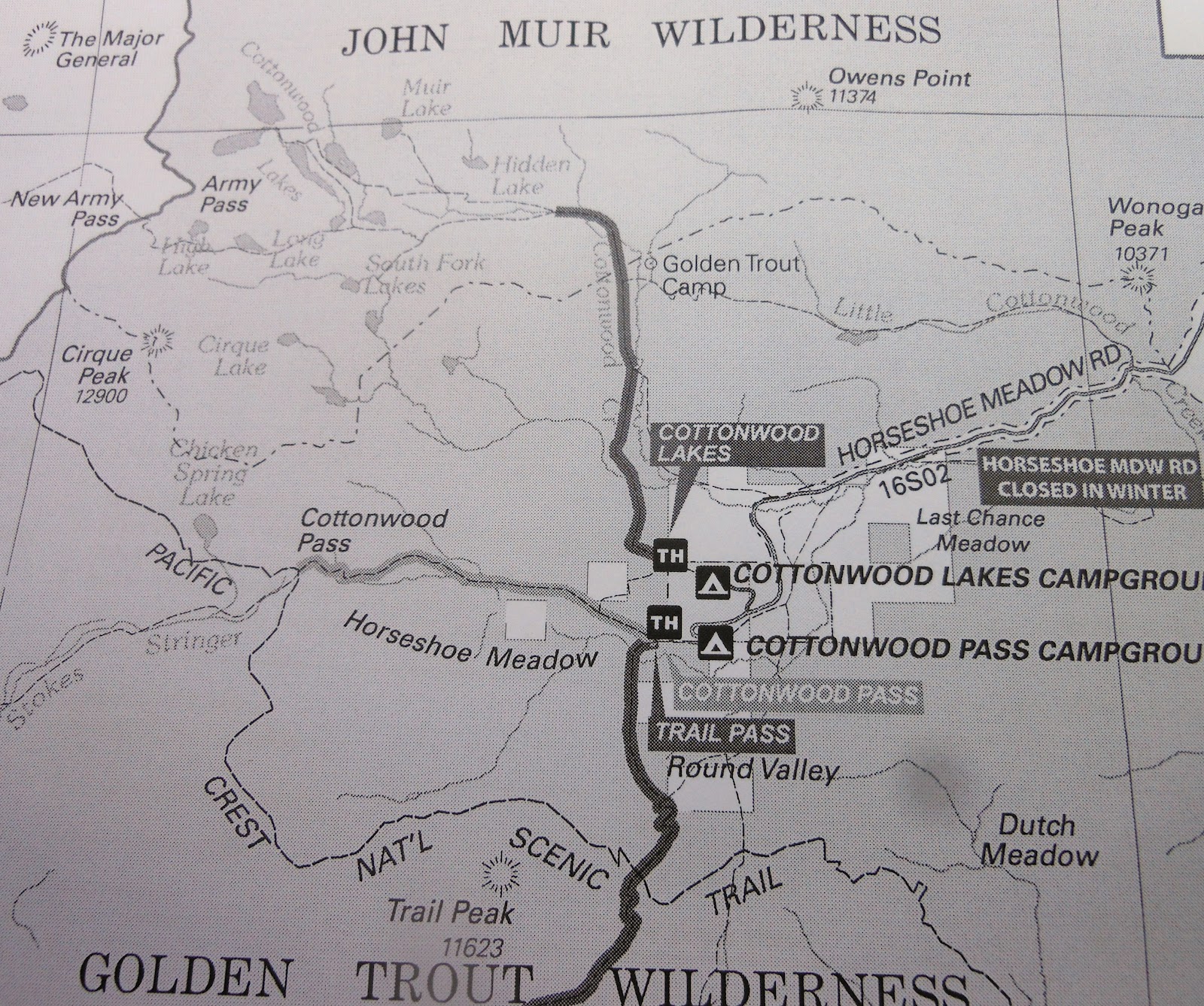
To hike the trail through Horseshoe Meadow to Cottonwood Pass
Day #577 * Hike #669 * New Track #573
Thursday June 14, 2012
Cottonwood Pass - Trail Pass - Mount Whitney - Lone Pine, CA
Big Whitney Meadows - Chicken Spring Lake - Pacific Crest Trail (PCT)
My Tripometer: 5 Hours * 8 Miles * +1525 Feet
Trailhead 9940 Feet
Looking across the meadows, but we don't go that way
The trail is easy to follow
Cross two gentle streams and then march through a forest
The climb begins...
We counted 40 total switchbacks but they weren't that difficult
Okay, it's a bit of a push to the top...
Looking back, the air up here is thinner
when I bent down to tie my shoe, I almost fainted
Ayden mustered the will to do this!
His steps were actually quicker than mine. He was hopping around up here like he was at sea level. The only problem is that he was bored and wanted to turn back early on. I entertained him by nonstop talking about guy stuff. This entertained him but I lost my breath doing it. I prefer hiking and breathing, no music, no talking, just peace. Meanwhile, Ayden will ask questions and then ask questions of questions repeitively. He just never stops... Talking is more exhausting than hiking...
Cottonwood Pass Elevation 11,130 Feet!
This is the highest elevation that I have ever hiked to. Of course this is Ayden's highest peak as well. Although I believe I was very close when I was on Mount Charleston so this may be debateable.
Cottonwood Pass represents the junction of the Pacific Crest Trail. Our initial goal was to make it here and then turn back, but.... hmm, where should we go. I recalled seeing Chicken Spring Lake on the map. I thought it was straight but Ayden said that it was right. However, the right said Rock Creek so I was like, let's just go straight, it makes sense. Well, as it turns out he was right. The lake was just up here:
PCT Trail to Chicken Spring Lake
(The trail also leads all the way to Mt. Whitney!)
PCT to the south
After hiking across the upper plain, the trail heads lower
Mt. Whitney in the far distance
The trail leads down to the Big Whitney Meadows
A bee caught by a spiderweb and the spider is creeping toward for the sting
We turned around here because the weather was quickly turning. Out of nowhere we heard a rumble of thunder and the clouds were closing in. It also became cooler so we had to rush all the way up to the pass before finally reaching the switchbacks for the downhill slide.
Okay, let's hike back to camp, just 3.4 miles to go
Looking back up at the top...
Back near the creek at the bottom a trail lead to this abandoned cabin
Finally back at camp
It was 5:30pm and many of the camping spots were filled. Our neighbor had a 7 year old boy and Ayden hung out with him for the majority of the night. His father told me that his son does MMA and is ranked 7th in the state. He had just recently broke his arm for a second time, on the monkey bars for the second time. I haven't checked it out yet but he is said to have a YouTube channel. "HardHeadedReuben2004". I've been meaning to check it but even right now, just trying to get through this post so I can go to bed :)
Bear Canister
Ayden's Spear to defend the bears, or eat sausage and marshmellows
Ayden tending the fire at night
It was a very cold night, but we survived okay. No thunderstorms, just icy frost on the tent in the A.M. We left camp early without breakfast to begin our final day of the trip. Today I will see my parents for the first time in 18 months!
Lake Diaz and the city of Lone Pine below...
My backup plan was to camp at Lake Diaz, so glad we didn't!
Hey, if you were an 8-year-old boy, wouldn't you do this too?!