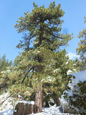
Amazing Trees at Chorro Springs
Day #517 * Hike #595 * New Track #521
Sunday April 15, 2012
Chorro Grande Trail - Chorro Springs
Chorro Grande Trail - Chorro Springs
Sespe Wilderness, Los Paderes National Forest
My Tripometer: 5 Hours * 9.25 Mile * +2850 Feet
Taking the Scenic Drive up the 33 past Ojai
Directions:
From Ojai, continue North up the 33. Pass the two tunnels and the Ranger Station at Wheeler Gorge. Keep going all the way up past 4000 feet. The trailhead will be exactly 11.0 miles past Rosevalley on the right.
The Trailhead (the sign has been ripped off)
4052 Feet Elevation - Parking on the left or right
Map of today's adventure
I recently bought the Matilija & Dick Smith Wilderness Map. This picture is from this map but it's actually located in the Sespe Wilderness (I have that map too). --I am so excited because for $8.95, this purchase has opened up a whole new back country from Ojai to Santa Barbara. The hiking looks insane!
We will conquer the mountain ahead!
Awesome Geology!
Snow at Oak Camp - 4569 Feet
I hiked to Chorro Springs about four years ago. I camped with some friends and remembered that there was some pretty deep snow up there. I did not recall seeing any snow last time at Oak. My intention today was to hike into the white stuff. We had some pretty nasty weather just a couple days ago...
Sammi seems to like it!
Not much past Oak Camp there is a fork to the right. TAKE THE RIGHT FORK! I remembered this from last time but just for fun, I went left again just to check in on it. I took some pics but they were not worthy for this post. The trail quickly ends but you could follow the stream. According to the map, a short trail crosses in each direction but I didn't see it...
Looking back - the switchbacks began at the fork
The trail scatters, find these two trees and stay right
I recalled last time my buddy Chris was about 100 feet ahead of me. It was a very tough climb with the heavy packs on. He chanted, "One Step at a Time, One Step at a Time:... For a moment, that gave me motivation but I found out quickly that was false because I charlie horsed! There was no snow at this elevation either last time. Today, no Charlie Horse but look what's up:
More than ankle deep for me at this height
(The drifts were higher than my dog!)
The deadly switchbacks end at the rocks
Don't let this mislead you. The trail continues to go higher and into the forest. The further you go in away from the sun exposed ledge, the deeper the snow gets. Last time, this is where the snow had began. Today, it was knee deep in places...
Looking to the North
To the south, the sky is clear all the way to the Ocean. However, the skies where not pristine to a point where the water and islands could be made out clearly. Some days, they just jump out at you...
Just a few strides away from Camp
It was way cool and creepy back here today. You are walking through shade and the snow covered trees are raining. It sounds like it's pouring and look out for icicles and heavy snow falling. No footsteps up here, Just Sammi and I!
The camp stove is buried
Welcome to Paradise!
The Chorro Springs
Water naturally comes up from the Earth under this rock
What kind of tree is this?
There are two like it up here, bigger than the rest
Animal Pee? Let's get out of here!
Great experience up here today. It would have been nearly impossible to go any higher. In the summertime, the trail extends another 0.8 miles to Reyes Peak Road (Pine Mountain Road). This road is only open seasonally from the summit off the 33. Chorro Springs has an elevation of 6464 feet and the road sits at 7162 feet. If you turn right and hike another 2.2 miles, you can reach the summit of Reyes Peak which stands at 7514 feet. Hmm, maybe next time :)...


Wow, amazing place, lovely pictures! I miss so much winter and the snow powder!
ReplyDeleteGreets,
Holiday Rentals Saas Fee
fjk7820ls4
ReplyDeletegolden goose outlet
golden goose outlet
golden goose outlet
golden goose outlet
golden goose outlet
golden goose outlet
supreme outlet
golden goose outlet
golden goose outlet
golden goose outlet